File:LocationMacedonia.png
Jump to navigation
Jump to search
No higher resolution available.
LocationMacedonia.png (250 × 115 pixels, file size: 6 KB, MIME type: image/png)
Summary
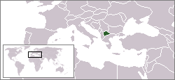
| Description |
English: Location map of the Republic of Macedonia.
Deutsch: Karte zur Lage der Republik Mazedonien. |
| Date | |
| Source | Originally created for English Wikipedia by Vardion. |
| Author | Vardion |

|
File:Location Republic Of Macedonia.svg is a vector version of this file. It should be used in place of this PNG file when not inferior.
File:LocationMacedonia.png → File:Location Republic Of Macedonia.svg
For more information, see Help:SVG. |
 |
Licensing
| |
This work has been released into the public domain by its author, Vardion, at the English Wikipedia project. This applies worldwide. In case this is not legally possible: |
File history
Click on a date/time to view the file as it appeared at that time.
| Date/Time | Thumbnail | Dimensions | User | Comment | |
|---|---|---|---|---|---|
| current | 16:54, 6 June 2006 | | 250 × 115 (6 KB) | commons>Rain74 | Montenegro |
File usage
There are no pages that use this file.