File:Linate Airport disaster map en.gif
Jump to navigation
Jump to search

Size of this preview: 360 × 599 pixels. Other resolutions: 144 × 240 pixels | 288 × 480 pixels | 462 × 768 pixels | 1,109 × 1,844 pixels.
Original file (1,109 × 1,844 pixels, file size: 31 KB, MIME type: image/gif)
File history
Click on a date/time to view the file as it appeared at that time.
| Date/Time | Thumbnail | Dimensions | User | Comment | |
|---|---|---|---|---|---|
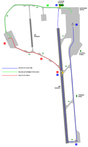
| current | 12:05, 30 July 2008 | | 1,109 × 1,844 (31 KB) | commons>Apalsola | {{Information |Description= {{en|1=Map showing the routes of the aircraft involved at Linate Airport disaster at Linate Airport (LIN/LIML) in Milan, Italy on 2001-10-08.}} {{fi|1=Kartta Milanon lento-onnettomuuden o |
File usage
There are no pages that use this file.