File:La francophonie mapa.svg
Jump to navigation
Jump to search

Size of this PNG preview of this SVG file: 800 × 353 pixels. Other resolutions: 320 × 141 pixels | 640 × 283 pixels | 1,024 × 452 pixels | 1,280 × 565 pixels | 2,560 × 1,131 pixels | 1,003 × 443 pixels.
Original file (SVG file, nominally 1,003 × 443 pixels, file size: 1.44 MB)
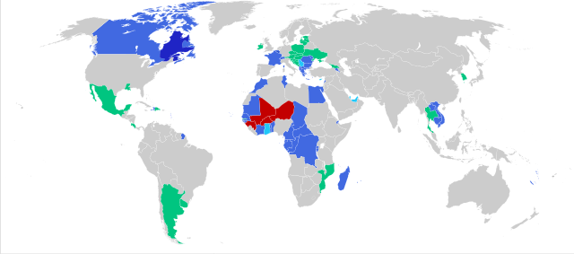
Summary
| Description |
Français : Carte de la Francophonie
membre (national)
membre (régional)
membre associé
membre suspendu
observateur Español: Mapa de la Francofonía
miembro (nacional)
miembro (regional)
miembro asociado
miembro suspendido
observador English: Map of the Francophonie
member (national)
member (regional)
associated member
suspended member
observer Nederlands: Kaart van de Francofonie
lid (nationaal)
lid (regionaal)
geassocieerd lid
geschorst lid
waarnemer |
| Date | |
| Source | File:Map-Francophonie organisation fr.svg |
| Author | Bourrichon |
What happened to Newfoundland and Labrador 💀
Licensing
| I, the copyright holder of this work, release this work into the public domain. This applies worldwide. In some countries this may not be legally possible; if so: I grant anyone the right to use this work for any purpose, without any conditions, unless such conditions are required by law. |
File history
Click on a date/time to view the file as it appeared at that time.
| Date/Time | Thumbnail | Dimensions | User | Comment | |
|---|---|---|---|---|---|
| current | 21:25, 15 November 2023 | | 1,003 × 443 (1.44 MB) | commons>HapHaxion | further coup suspensions // Editing SVG source code using c:User:Rillke/SVGedit.js |
File usage
There are no pages that use this file.