File:Kuril Benioff zone.JPG
Jump to navigation
Jump to search
No higher resolution available.
Kuril_Benioff_zone.JPG (425 × 305 pixels, file size: 17 KB, MIME type: image/jpeg)
File history
Click on a date/time to view the file as it appeared at that time.
| Date/Time | Thumbnail | Dimensions | User | Comment | |
|---|---|---|---|---|---|
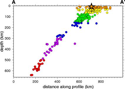
| current | 09:35, 26 May 2009 | | 425 × 305 (17 KB) | commons>Mikenorton | {{Information |Description={{en|1=Seismicity cross-section across part of the Kuril Islands subduction zone}} |Source=USGS page on Kuril earthquake 2006 [http://neic.usgs.gov/neis/eq_depot/2006/eq_061115_vcam/neic_vcam_c.html] |Author=USGS |Date=2006-11 | |
File usage
There are no pages that use this file.