File:Krupac – Stećci (03).jpg

Original file (2,448 × 3,264 pixels, file size: 2.23 MB, MIME type: image/jpeg)
.jpg)
Summary
| Description |
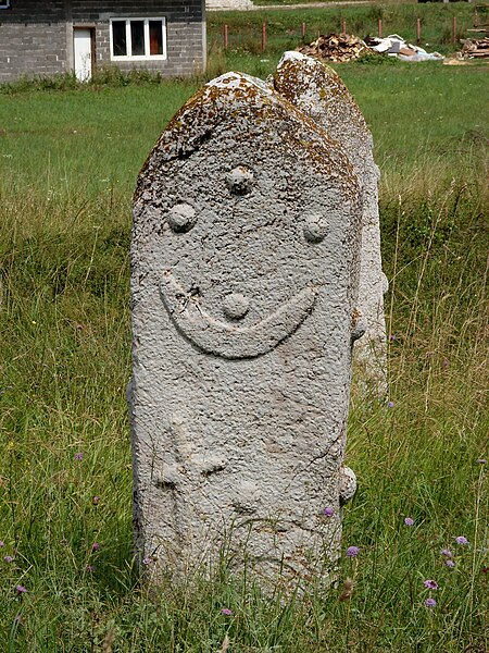
Deutsch: Stećak (bosnischer Grabstein) im Dorf Vojkovići nahe Sarajevo
English: Stećak (bosnian gravestone) in Vojkovići village near Sarajevo
Hornjoserbsce: Stećak (bosniski narowny kamjeń) we Vojkovićach blisko Sarajevo |
| Date | |
| Source | Own work |
| Author | Julian Nyča |
| Permission (Reusing this file) |
 Die kostenlose Weiternutzung dieses Bildes, insbesondere kommerzieller Natur, ist im Sinne der unten genannten Lizenz nur unter folgender Bedingung gestattet:
Durch die Bildnutzung erklären Sie sich mit den Lizenzbedingungen einverstanden. Im Falle eines Verstoßes gegen die Lizenzbedingungen erlöschen die Nutzungsrechte automatisch. Ich behalte mir vor, in diesem Fall ein nachträgliches Nutzungsentgelt in Rechnung zu stellen. Werden größere Versionen des Bildes oder eine Nutzung ohne Namensnennung gewünscht, bitte vorher hier anfragen!
 Bjezpłatne dalewužiwanje tutoho wobraza, wosebje komercielneho razu, je w zmysle podateje licency jenož pod slědowacym wuměnjenjom dowolene:
Z wužiwanjom wobraza akceptujeće licencowe wuměnjenja. W padźe zranjenja licencowych wuměnjenjow wužiwanske prawo awtomatisce zhubiće.
Weitere Bilder von Julian Nyča: alle – nur aus dem Album Sarajevo – nur von 2008 Kontakt für Anfragen: julian.nyca (at) luzica.la |
| Camera location | | View this and other nearby images on: OpenStreetMap |
|---|
.jpg¶ms=043.780275_N_0018.360455_E_globe:Earth_type:camera_alt:539.6_source:exif_&language=en)
Licensing

|
Permission is granted to copy, distribute and/or modify this document under the terms of the GNU Free Documentation License, Version 1.2 or any later version published by the Free Software Foundation; with no Invariant Sections, no Front-Cover Texts, and no Back-Cover Texts. A copy of the license is included in the section entitled GNU Free Documentation License. |
- You are free:
- to share – to copy, distribute and transmit the work
- to remix – to adapt the work
- Under the following conditions:
- attribution – You must give appropriate credit, provide a link to the license, and indicate if changes were made. You may do so in any reasonable manner, but not in any way that suggests the licensor endorses you or your use.
- share alike – If you remix, transform, or build upon the material, you must distribute your contributions under the same or compatible license as the original.
File history
Click on a date/time to view the file as it appeared at that time.
| Date/Time | Thumbnail | Dimensions | User | Comment | |
|---|---|---|---|---|---|
| current | 14:53, 1 February 2011 | | 2,448 × 3,264 (2.23 MB) | commons>J budissin | {{Information |Description= {{de|Stećak (bosnischer Grabstein) im Dorf Vojkovići nahe Sarajevo}} {{en|Stećak (bosnian gravestone) in Vojkovići village near Sarajevo}} {{hsb|Stećak (bosniski narowny kamjeń) we Vojkov |
File usage
There are no pages that use this file.
.jpg)