File:Knowl House Mirfield 2575778 251aa4db.jpg
From WikiProjectMed
Jump to navigation
Jump to search
![File:Knowl House Mirfield 2575778 251aa4db.jpg](https://upload.wikimedia.org/wikipedia/commons/thumb/a/a0/Knowl_House_Mirfield_2575778_251aa4db.jpg/800px-Knowl_House_Mirfield_2575778_251aa4db.jpg)
Size of this preview: 800 × 579 pixels. Other resolutions: 320 × 232 pixels | 640 × 463 pixels | 848 × 614 pixels.
Original file (848 × 614 pixels, file size: 112 KB, MIME type: image/jpeg)
This file is from a shared repository and may be used by other projects. The description on its file description page there is shown below.
Summary
DescriptionKnowl House Mirfield 2575778 251aa4db.jpg |
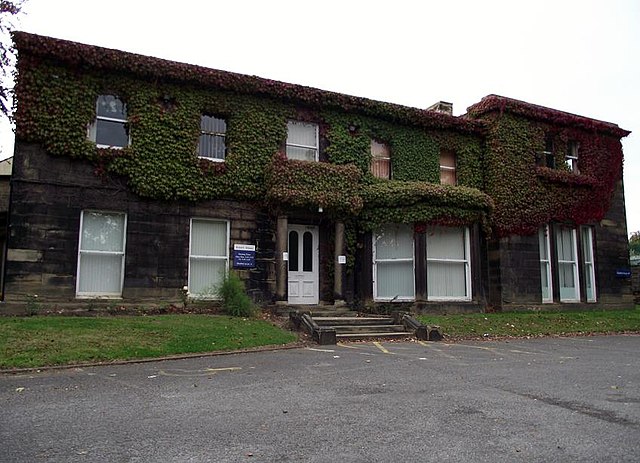
English: Knowl House, Knowl Road, Mirfield. A large stone built historic building set in its own grounds with large carpark to the front. It housed Kirklees Council's Street Scene dept. This dept is responsible for eg refuse collection, street maintenance etc. There is a plant nursery to the rear. A few years ago MAFF officers were based here. Originally it was the home of the Walker family who owned James Walker & Sons, carpet manufacturers at Holme Bank and Butt End Mills, Mirfield. They donated the house to Kirklees Council, who sold it in 2013. The artist Hilda Annetta Walker lived here with her family until at least 1911. |
||
Date | |||
Source | From geograph.org.uk | ||
Author | Chris Pattinson | ||
Permission (Reusing this file) |
Creative Commons Attribution Share-alike license 2.0
![]() ![]() ![]() This file is licensed under the Creative Commons Attribution-Share Alike 2.0 Generic license. Attribution: Chris Pattinson
|
||
Attribution (required by the license) InfoField | Chris Pattinson / Knowl House, Knowl Road, Mirfield / | ||
InfoField | Chris Pattinson / Knowl House, Knowl Road, Mirfield |
Camera location | 53° 40′ 43.6″ N, 1° 41′ 47″ W ![]() ![]() | View this and other nearby images on: OpenStreetMap | ![]() |
---|
Object location | 53° 40′ 43.6″ N, 1° 41′ 47″ W ![]() ![]() | View this and other nearby images on: OpenStreetMap | ![]() |
---|
Captions
Add a one-line explanation of what this file represents
Items portrayed in this file
depicts
29 August 2011
53°40'43.608"N, 1°41'47.137"W
53°40'43.61"N, 1°41'47.15"W
0.01428571428571428571 second
3.1
5 millimetre
100
image/jpeg
File history
Click on a date/time to view the file as it appeared at that time.
Date/Time | Thumbnail | Dimensions | User | Comment | |
---|---|---|---|---|---|
current | 09:14, 21 July 2021 | ![]() | 848 × 614 (112 KB) | commons>Geograph Update Bot | Higher-resolution version from Geograph |
File usage
There are no pages that use this file.
Metadata
This file contains additional information, probably added from the digital camera or scanner used to create or digitize it.
If the file has been modified from its original state, some details may not fully reflect the modified file.
Camera manufacturer | FUJIFILM |
---|---|
Camera model | FinePix S1600 |
Exposure time | 1/70 sec (0.014285714285714) |
F Number | f/3.1 |
ISO speed rating | 100 |
Date and time of data generation | 05:46, 19 August 2011 |
Lens focal length | 5 mm |
Orientation | Normal |
Horizontal resolution | 72 dpi |
Vertical resolution | 72 dpi |
Software used | Microsoft Windows Live Photo Gallery14.0.8081.709 |
File change date and time | 21:01, 28 August 2011 |
Y and C positioning | Co-sited |
Exposure Program | Normal program |
Exif version | 2.2 |
Date and time of digitizing | 05:46, 19 August 2011 |
Meaning of each component |
|
Image compression mode | 2 |
APEX shutter speed | 6.1 |
APEX aperture | 3.26 |
APEX brightness | 4.39 |
APEX exposure bias | 0 |
Maximum land aperture | 3.26 APEX (f/3.1) |
Metering mode | Pattern |
Light source | Unknown |
Flash | Flash did not fire, compulsory flash suppression |
Supported Flashpix version | 1 |
Color space | sRGB |
Focal plane X resolution | 6,494 |
Focal plane Y resolution | 6,494 |
Focal plane resolution unit | 3 |
Sensing method | One-chip color area sensor |
File source | Digital still camera |
Scene type | A directly photographed image |