File:Keylong West Lahaul Himachal Oct22 A7C 03375 panorama.jpg
Jump to navigation
Jump to search
Size of this preview: 800 × 400 pixels. Other resolutions: 320 × 160 pixels | 640 × 320 pixels | 1,024 × 512 pixels | 1,280 × 640 pixels | 2,560 × 1,280 pixels | 5,624 × 2,812 pixels.
Original file (5,624 × 2,812 pixels, file size: 12.62 MB, MIME type: image/jpeg)
Summary
| Description |
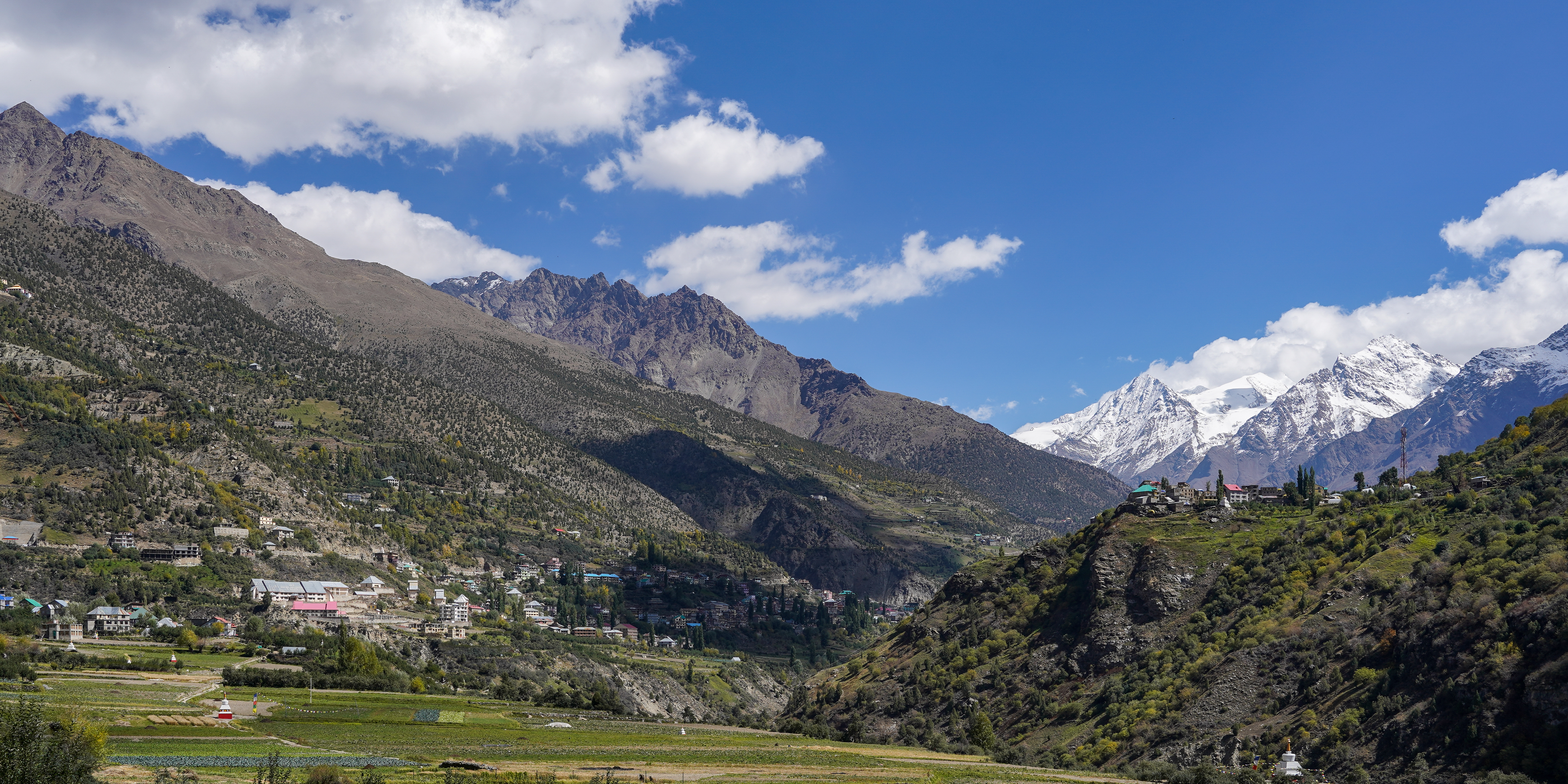
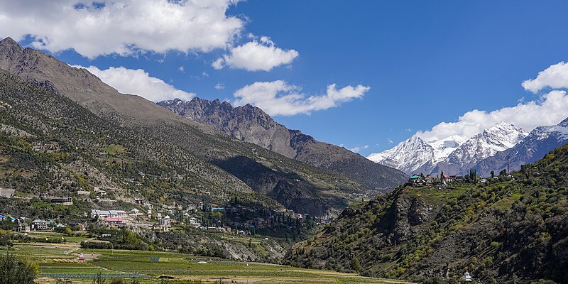
English: Keylong, fields of Belling in the foreground, Kardang on right. View from the west. Lahaul, Himachal, India.
Українська: Місто Кейлонг, поля Беллінга на передньому плані, село Карданг праворуч. Вигляд із заходу. Округ Лахаул, Гімачал-Прадеш, Індія.
Español: Vista desde el oeste de Keylong con los campos de Belling en primer plano y la aldea de Kardang a la derecha. Distrito de Lahaul, Himachal Pradesh, India. |
|||
| Date | ||||
| Source | ||||
| Author |
|


| Camera location | | View this and other nearby images on: OpenStreetMap |
|---|
The geographical information in this file was retrospectively estimated.
The location may therefore be somewhat imprecise. Verifying and refining these coordinates is strongly encouraged. |
Assessment
|
This image was selected as picture of the day on Wikimedia Commons for 25 March 2024. It was captioned as follows: English: Keylong, fields of Belling in the foreground, Kardang on right. View from the west. Lahaul, Himachal, India. Other languages:
Čeština: V popředí město Kyelang, pole Bellingu v pozadí snímku, vesnice Kardang vpravo při pohledu směrem na západ v indickém Lahaulu ve státě Himáčalpradéš. English: Keylong, fields of Belling in the foreground, Kardang on right. View from the west. Lahaul, Himachal, India. Español: Vista desde el oeste de Keylong con los campos de Belling en primer plano y la aldea de Kardang a la derecha. Distrito de Lahaul, Himachal Pradesh, India. Français : Vue de Keylong, avec des champs au premier plan et le village de Kardang à droite. District de Lahaul et Spiti, Himachal Pradesh (Inde). Italiano: Vista da ovest di Keylong, villaggio dell'India capoluogo del distretto di Lahaul e Spiti, nello stato federato dell'Himachal Pradesh. In primo piano si possono vedere i campi di Belling, mentre sulla destra si scorge il villaggio di Kardang. Magyar: Keylong látképe nyugatról, az előtérben Belling mezőivel, jobbra Kardang (Lahaul kerület, Himácsal Prades, India) Nederlands: Blik op Keylong, de hoofdstad van het district Lahul and Spiti in de Indiase deelstaat Himachal Pradesh Português: Vista do oeste de Keylong com os campos de Belling em primeiro plano e a aldeia de Kardang à direita. Distrito de Lahaul, Himachal Pradexe, Índia. Македонски: Предел во Лахаул, Химачал Прадеш, Индија. Русский: Вид на селение Карданг. Окрестности города Келанг, округ Лахул и Спити, штат Химачал-Прадеш, Индия Українська: Місто Кейлонг, поля Беллінга на передньому плані, село Карданг праворуч. Вигляд із заходу. Округ Лахаул, Гімачал-Прадеш, Індія. |
Licensing
This file is licensed under the Creative Commons Attribution-Share Alike 4.0 International license.
- You are free:
- to share – to copy, distribute and transmit the work
- to remix – to adapt the work
- Under the following conditions:
- attribution – You must give appropriate credit, provide a link to the license, and indicate if changes were made. You may do so in any reasonable manner, but not in any way that suggests the licensor endorses you or your use.
- share alike – If you remix, transform, or build upon the material, you must distribute your contributions under the same or compatible license as the original.
| Annotations | This image is annotated: View the annotations at Commons |
File history
Click on a date/time to view the file as it appeared at that time.
| Date/Time | Thumbnail | Dimensions | User | Comment | |
|---|---|---|---|---|---|
| current | 01:51, 4 October 2023 | | 5,624 × 2,812 (12.62 MB) | commons>Tagooty | c:User:Rillke/bigChunkedUpload.js: Fixed tilt in right side |
File usage
There are no pages that use this file.