File:KarstterrainUSGS.jpg
Jump to navigation
Jump to search

Size of this preview: 800 × 356 pixels. Other resolutions: 320 × 143 pixels | 640 × 285 pixels | 1,313 × 585 pixels.
Original file (1,313 × 585 pixels, file size: 273 KB, MIME type: image/jpeg)
File history
Click on a date/time to view the file as it appeared at that time.
| Date/Time | Thumbnail | Dimensions | User | Comment | |
|---|---|---|---|---|---|
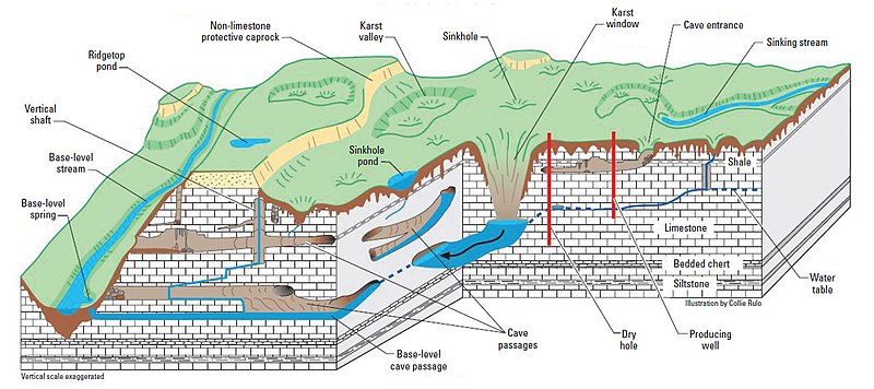
| current | 17:12, 9 December 2018 | | 1,313 × 585 (273 KB) | commons>RockDoc485 | Figure 1 in Taylor, Charles J., and Earl A. Greene. "Hydrogeologic characterization and methods used in the investigation of karst hydrology." US Geological Survey (2008). Chapter 3 of Field Techniques for Estimating Water Fluxes Between Surface Water and Ground Water, Edited by Donald O. Rosenberry and James W. LaBaugh, Techniques and Methods 4–D2. Available from USGS at https://pubs.usgs.gov/tm/04d02/pdf/TM4-D2-chap3.pdf Identified as "Figure 1. Physiographic and hydrologic features typica... |
File usage
There are no pages that use this file.