File:Kanem-Bornu 1650.svg
Jump to navigation
Jump to search

Size of this PNG preview of this SVG file: 424 × 600 pixels. Other resolutions: 170 × 240 pixels | 339 × 480 pixels | 543 × 768 pixels | 724 × 1,024 pixels | 1,448 × 2,048 pixels | 686 × 970 pixels.
Original file (SVG file, nominally 686 × 970 pixels, file size: 1.43 MB)
Summary
| Description |
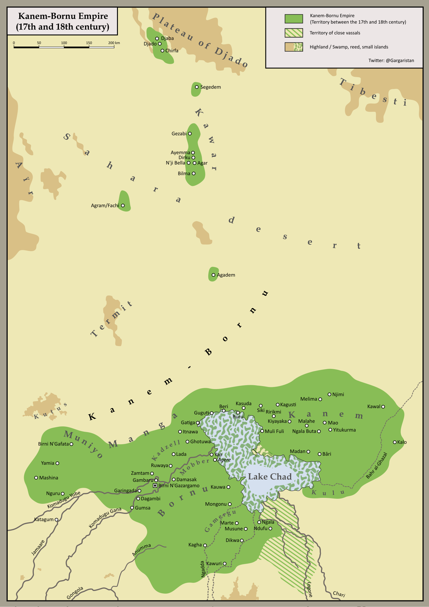
English: Map of the Kanem-Bornu Empire in the Sahel zone around Lake Chad in the 17th and 18th century.
Sources: "Eine Studie über Entstehung und Wandel eisenzeitlich-historischer Fürstentümer im südlichen Tschadbecken (7./ 8. Jahrhundert n. Chr. bis ca. 1925)" by Detlef Gronenborn, "Al-Qasaba et d'autres villes de la route centrale du Sahara" by Dierk Lange and Silvio Berthoud, "Origin and Meaning of Damagaram" by Babagana Abubakar and other documents. |
| Date | |
| Source | Own work |
| Author | Ermanarich |
Licensing
I, the copyright holder of this work, hereby publish it under the following license:
This file is licensed under the Creative Commons Attribution-Share Alike 4.0 International license.
- You are free:
- to share – to copy, distribute and transmit the work
- to remix – to adapt the work
- Under the following conditions:
- attribution – You must give appropriate credit, provide a link to the license, and indicate if changes were made. You may do so in any reasonable manner, but not in any way that suggests the licensor endorses you or your use.
- share alike – If you remix, transform, or build upon the material, you must distribute your contributions under the same or compatible license as the original.
File history
Click on a date/time to view the file as it appeared at that time.
| Date/Time | Thumbnail | Dimensions | User | Comment | |
|---|---|---|---|---|---|
| current | 18:42, 2 October 2020 | | 686 × 970 (1.43 MB) | commons>Ermanarich | Converted text into objects so it's shown properly |
File usage
There are no pages that use this file.