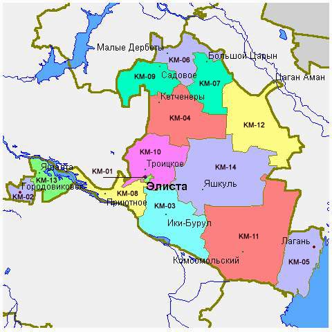
File:Kalmykia03.png
Jump to navigation
Jump to search

Size of this preview: 680 × 600 pixels. Other resolutions: 272 × 240 pixels | 544 × 480 pixels | 738 × 651 pixels.
Original file (738 × 651 pixels, file size: 44 KB, MIME type: image/png)
Summary
- Map of the Republic of Kalmykia.
Source and license

|
This map has been uploaded by Electionworld from en.wikipedia.org to enable the |
Map made by PANONIAN
| This work has been released into the public domain by its author, PANONIAN. This applies worldwide. In some countries this may not be legally possible; if so: |
References
Maps of Kalmykia:
- http://www.mapzones.com/citymap/russia/republic_of_kalmykia/republic_of_kalmykia.jpg
- http://www.eatingahobo.com/kalmykia01.gif
- https://www.usrbc.org/pics/Image/Russian%20Regions/Kalmykia%20Republic/map_kalmyk.gif
- http://www.zum.de/whkmla/histatlas/russia/kalmykia.gif
- http://www.rdaward.org/map/6i.jpg
- http://farm4.static.flickr.com/3050/3255735175_fd4c1a7b79.jpg
- http://files.vector-images.com/clipart/kalmykia_map.gif
- http://farm3.staticflickr.com/2358/2163150592_33a3152774.jpg
- http://www.regions.newsall.ru/kalmykia/kalmykia.htm.gif
- http://www.tatneft.ru/wps/wcm/jsp/getImage.jsp?content_id=com.ibm.workplace.wcm.api.WCM_Content/news_2009.05.12_16.18.03.669/db640a804e13769483b6b7f586c5a29c/PUBLISHED&name=image
Largest settlements in Kalmykia:
File history
Click on a date/time to view the file as it appeared at that time.
| Date/Time | Thumbnail | Dimensions | User | Comment | |
|---|---|---|---|---|---|
| current | 10:48, 14 May 2012 | | 738 × 651 (44 KB) | commons>PANONIAN | Reverted to version as of 09:07, 14 May 2012 - trying to fix thumbnail problem once more |
File usage
There are no pages that use this file.