File:Israel and the Disputed Territories map.png
Jump to navigation
Jump to search

Size of this preview: 352 × 600 pixels. Other resolutions: 141 × 240 pixels | 282 × 480 pixels | 451 × 768 pixels | 601 × 1,024 pixels | 1,350 × 2,300 pixels.
Original file (1,350 × 2,300 pixels, file size: 1.39 MB, MIME type: image/png)
File history
Click on a date/time to view the file as it appeared at that time.
| Date/Time | Thumbnail | Dimensions | User | Comment | |
|---|---|---|---|---|---|
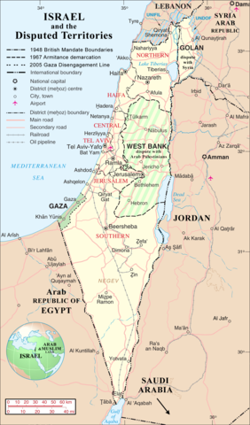
| current | 18:03, 1 April 2007 | | 1,350 × 2,300 (1.39 MB) | commons>Jaakobou | == Summary == {{Information |Description= {{en|Map of Israel, [http://en.wikipedia.org/wiki/Palestinian_territories Palestinian Controlled Territories of] (Gaza and the West Bank), the Golan Heights, and neighbouring countries. |
File usage
There are no pages that use this file.