File:Huntington SR Box 20(01).04.jpg
Jump to navigation
Jump to search

Size of this preview: 383 × 599 pixels. Other resolutions: 153 × 240 pixels | 307 × 480 pixels | 491 × 768 pixels | 655 × 1,024 pixels | 1,310 × 2,048 pixels | 3,623 × 5,665 pixels.
Original file (3,623 × 5,665 pixels, file size: 2.65 MB, MIME type: image/jpeg)
.04.jpg)
File history
Click on a date/time to view the file as it appeared at that time.
| Date/Time | Thumbnail | Dimensions | User | Comment | |
|---|---|---|---|---|---|
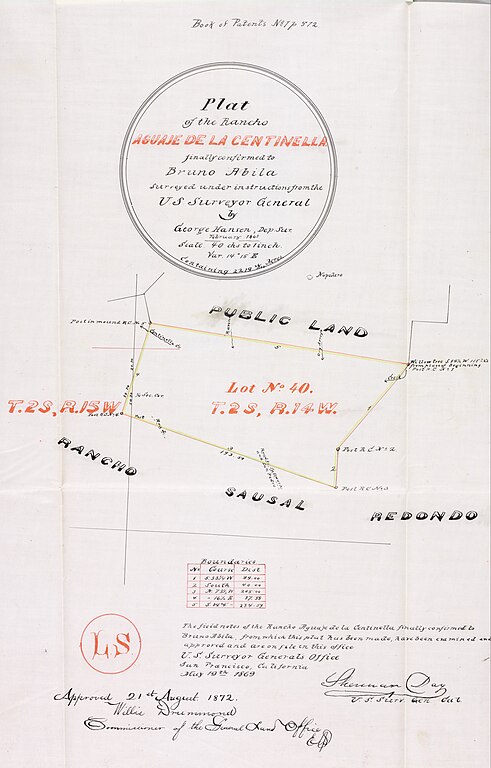
| current | 03:54, 22 November 2023 | | 3,623 × 5,665 (2.65 MB) | commons>Jengod | Uploaded a work by U.S. Surveyor General from Title Plat of the Rancho Aguaje de la Centinela finally confirmed to Bruno Abila. Creator Hansen, George, 1824-1897, creator. Date Searchable 1868-02 Date 1868 February Call Number SR_Box_20(01).04 Physical Description 1 ms. map ; 6 x 8 in., on sheet 19 x 11 1/4 in., ink on tracing cloth Scale 1 : 40 chains Location depicted Inglewood Description Adjacent T. 2 S., R. 15 W., public land and Rancho Sausal Redondo. Color highlighted Lot No. 40 T. 2 S... |
File usage
There are no pages that use this file.
.04.jpg)