File:Harricana map.png
Jump to navigation
Jump to search
No higher resolution available.
Harricana_map.png (359 × 254 pixels, file size: 19 KB, MIME type: image/png)
Summary
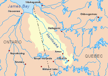
| Description |
English: Drainage basin of the Harricana River, Quebec and Ontario, Canada. |
| Source | Own work based on info from Atlas of Canada |
| Author | P199 |
Licensing
| I, the copyright holder of this work, release this work into the public domain. This applies worldwide. In some countries this may not be legally possible; if so: I grant anyone the right to use this work for any purpose, without any conditions, unless such conditions are required by law. |
File history
Click on a date/time to view the file as it appeared at that time.
| Date/Time | Thumbnail | Dimensions | User | Comment | |
|---|---|---|---|---|---|
| current | 23:49, 23 November 2008 | | 359 × 254 (19 KB) | commons>P199 | {{Information |Description={{en|1=Drainage basin of the Harricana River, Quebec and Ontario, Canada.}} |Source=Own work based on info from [http://atlas.nrcan.gc.ca/site/english/maps/environment/hydrology/drainagebasins Atlas of Canada] |Author=[[User:P19 |
File usage
There are no pages that use this file.