File:Harington Point.jpg
Jump to navigation
Jump to search

Size of this preview: 800 × 441 pixels. Other resolutions: 320 × 176 pixels | 640 × 353 pixels | 1,024 × 565 pixels | 1,280 × 706 pixels | 2,560 × 1,412 pixels | 4,896 × 2,700 pixels.
Original file (4,896 × 2,700 pixels, file size: 5.18 MB, MIME type: image/jpeg)
Summary
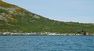
| Description | Harington Point on the Otago Peninsula |
| Date | |
| Source | Own work |
| Author | Pseudopanax at English Wikipedia |
| Camera location | | View this and other nearby images on: OpenStreetMap |
|---|
Licensing
| I, the copyright holder of this work, release this work into the public domain. This applies worldwide. In some countries this may not be legally possible; if so: I grant anyone the right to use this work for any purpose, without any conditions, unless such conditions are required by law. |
File history
Click on a date/time to view the file as it appeared at that time.
| Date/Time | Thumbnail | Dimensions | User | Comment | |
|---|---|---|---|---|---|
| current | 02:24, 7 February 2014 | | 4,896 × 2,700 (5.18 MB) | commons>Pseudopanax | == {{int:filedesc}} == {{Information |Description=Harington Point on the Otago Peninsula |Source={{Own}} |Date=2013-10-01 |Author={{user at project|Pseudopanax|wikipedia|en}} }} {{location|45|47|26|S|170|... |
File usage
There are no pages that use this file.