File:Guadeloupe Grande-Terre Places of interest map-fr.svg
Jump to navigation
Jump to search

Size of this PNG preview of this SVG file: 707 × 599 pixels. Other resolutions: 283 × 240 pixels | 566 × 480 pixels | 906 × 768 pixels | 1,208 × 1,024 pixels | 2,416 × 2,048 pixels | 920 × 780 pixels.
Original file (SVG file, nominally 920 × 780 pixels, file size: 498 KB)
Summary
| Description |
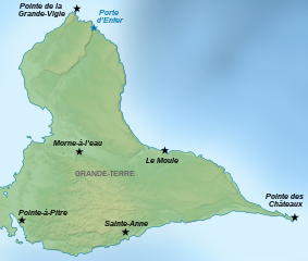
English: Map of places of interest in Grande-Terre, the second-in-size island of Guadeloupe, a French archipelago in the Antilles.
Français : Carte de lieux touristiques de Grande-Terre, la seconde île en superficie de la Guadeloupe, un archipel français des Antilles. Son appellation vient de sa comparaison avec Petite Terre des Saintes.la
Українська: Карта визначних місць на Гранде-Терре, другому за розміром острові Гваделупи, французькому архіпелазі на Антильських островах. |
||
| Date | |||
| Source | travail personnel (own work). Source : Image:Guadeloupe Places of interest map-fr.svg by Sémhur under licence GFDL & CC-BY-SA. | ||
| Author | Sémhur | ||
| Other versions |
| ||
| Attribution (required by the license) | © Sémhur / Wikimedia Commons / | ||
| SVG | W3C-validity not checked.
|
||
| Graphic Lab |


| Camera location | | View this and other nearby images on: OpenStreetMap |
|---|
Licensing
I, the copyright holder of this work, hereby publish it under the following licenses:
| Copyleft: This work of art is free; you can redistribute it and/or modify it according to terms of the Free Art License. You will find a specimen of this license on the Copyleft Attitude site as well as on other sites. |
This file is licensed under the Creative Commons Attribution-Share Alike 4.0 International, 3.0 Unported, 2.5 Generic, 2.0 Generic and 1.0 Generic license.
- You are free:
- to share – to copy, distribute and transmit the work
- to remix – to adapt the work
- Under the following conditions:
- attribution – You must give appropriate credit, provide a link to the license, and indicate if changes were made. You may do so in any reasonable manner, but not in any way that suggests the licensor endorses you or your use.
- share alike – If you remix, transform, or build upon the material, you must distribute your contributions under the same or compatible license as the original.
You may select the license of your choice.
File history
Click on a date/time to view the file as it appeared at that time.
| Date/Time | Thumbnail | Dimensions | User | Comment | |
|---|---|---|---|---|---|
| current | 17:01, 7 November 2022 | | 920 × 780 (498 KB) | commons>Antimuonium | moved Porte d'Enfer to its actual position |
File usage
There are no pages that use this file.