File:Grand Trunk Road Route.png
Jump to navigation
Jump to search

Size of this preview: 561 × 599 pixels. Other resolutions: 225 × 240 pixels | 449 × 480 pixels | 719 × 768 pixels | 959 × 1,024 pixels | 1,474 × 1,574 pixels.
Original file (1,474 × 1,574 pixels, file size: 2.1 MB, MIME type: image/png)
Wrong map Kashmir shown in Pakistan territory
Summary
| Description |
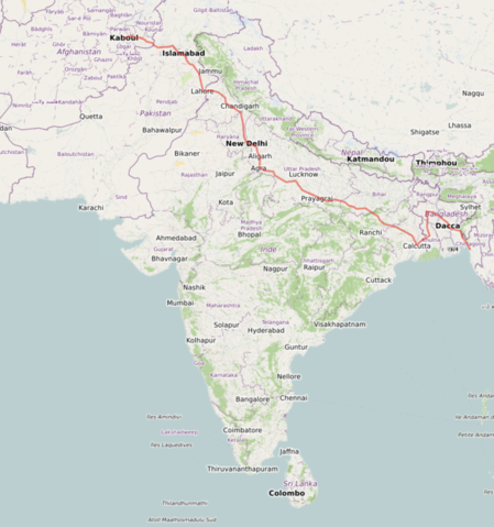
English: Route of the Grand Trunk Road rendered with Open Street Maps. Course of the road is constructed from historical data on the waypoints of the path as found in the article. |
| Date | |
| Source | Own work |
| Author | Lucas(CA2) |
Wrong
Licensing
I, the copyright holder of this work, hereby publish it under the following license:
This file is licensed under the Creative Commons Attribution-Share Alike 4.0 International license.
- You are free:
- to share – to copy, distribute and transmit the work
- to remix – to adapt the work
- Under the following conditions:
- attribution – You must give appropriate credit, provide a link to the license, and indicate if changes were made. You may do so in any reasonable manner, but not in any way that suggests the licensor endorses you or your use.
- share alike – If you remix, transform, or build upon the material, you must distribute your contributions under the same or compatible license as the original.
File history
Click on a date/time to view the file as it appeared at that time.
| Date/Time | Thumbnail | Dimensions | User | Comment | |
|---|---|---|---|---|---|
| current | 19:55, 5 March 2023 | | 1,474 × 1,574 (2.1 MB) | commons>Lucas(CA2) | Uploaded own work with UploadWizard |
File usage
There are no pages that use this file.