File:Gleisplan Saignelégier 1896.png
Jump to navigation
Jump to search

Size of this preview: 800 × 326 pixels. Other resolutions: 320 × 130 pixels | 640 × 261 pixels | 1,227 × 500 pixels.
Original file (1,227 × 500 pixels, file size: 439 KB, MIME type: image/png)
Summary
| Description |
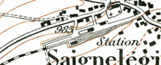
Deutsch: Vor 1904 war Saignelégier Endbahnhof der schmalspurigen Saignelégier–La Chaux-de-Fonds-Bahn. |
| Date | |
| Source | Topographischer Atlas der Schweiz (Siegfriedatlas) |
| Author | Eidgenössisches Stabsbureau (heute: Bundesamt für Landestopografie swisstopo) |
Licensing
The data made publicly available by swisstopo may be used, distributed and made accessible. Furthermore, they may be enriched and processed and also used commercially. A reference to the source is mandatory. In the case of digital or analogue representations and publications, as well as in the case of dissemination, one of the following source references must be attached in any case:
Terms of use for free geodata and geoservices (OGD) from swisstopo
|
.svg) |
File history
Click on a date/time to view the file as it appeared at that time.
| Date/Time | Thumbnail | Dimensions | User | Comment | |
|---|---|---|---|---|---|
| current | 20:17, 21 November 2015 | 1,227 × 500 (439 KB) | commons>Plutowiki | Teil des Bilds unten abgeschnitten |
File usage
There are no pages that use this file.