File:Gardiki Castle.jpg

Original file (1,250 × 830 pixels, file size: 1.07 MB, MIME type: image/jpeg)
Summary
| Description |
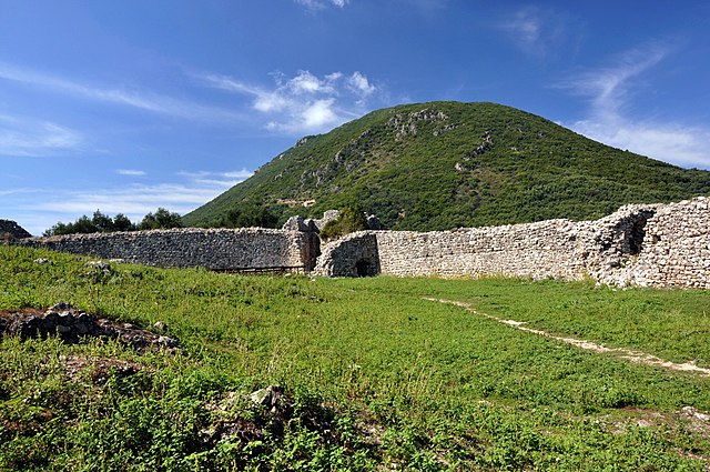
Gardiki in Corfu is a low foothill of the Agios Matheos mountain range on which stands the ruined Byzantine fortress. It was built as part of a ring of fortifications around the island, of which today only this one, Angelokastro and Cassiopi remain. Gardiki Castle was constructed in the 13th century by the Despote of Epirus, Michael Angelos II, who also built Angelokastro. The fortress is octagonal in shape and it has got a tower in every corner. What is particularly interesting here is the relics of ancient temples, which are embedded in its fortifications. The bordering parapets were adorned with traditional Byzantine artworks. The vestiges that one can see on the right hand side of the main entrance are believed to belong to the in-house chapel. It is not known when and why the castle was abandoned, but certainly in the 16th century after Barbarossa's attack (1537) it was already deserted. |
| Date | |
| Source |
|
| Author | Robin from Kraków, Poland |
| Camera location | | View this and other nearby images on: OpenStreetMap |
|---|
Licensing
- You are free:
- to share – to copy, distribute and transmit the work
- to remix – to adapt the work
- Under the following conditions:
- attribution – You must give appropriate credit, provide a link to the license, and indicate if changes were made. You may do so in any reasonable manner, but not in any way that suggests the licensor endorses you or your use.
| This image, originally posted to Flickr, was reviewed on January 10, 2011 by the administrator or reviewer File Upload Bot (Magnus Manske), who confirmed that it was available on Flickr under the stated license on that date. |
File history
Click on a date/time to view the file as it appeared at that time.
| Date/Time | Thumbnail | Dimensions | User | Comment | |
|---|---|---|---|---|---|
| current | 07:30, 20 February 2016 | | 1,250 × 830 (1.07 MB) | commons>Εὐθυμένης | better colors |
File usage
There are no pages that use this file.