File:Future Hurontario LRT Map.svg
Jump to navigation
Jump to search

Size of this PNG preview of this SVG file: 354 × 599 pixels. Other resolutions: 142 × 240 pixels | 283 × 480 pixels | 453 × 768 pixels | 604 × 1,024 pixels | 1,209 × 2,048 pixels | 623 × 1,055 pixels.
Original file (SVG file, nominally 623 × 1,055 pixels, file size: 606 KB)
Summary
| Description |
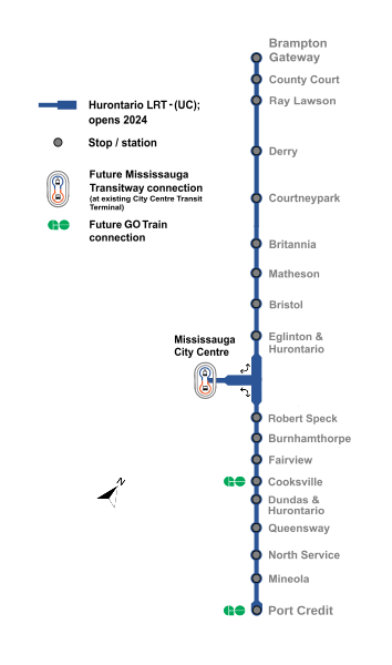
English: Schematic map of the Hurontario LRT in Mississauga and Brampton, Ontario. Thick lines indicate grade-separated sections. |
| Date | |
| Source | Own work |
| Author | Transportfan70 |
Licensing
I, the copyright holder of this work, hereby publish it under the following license:
| This file is made available under the Creative Commons CC0 1.0 Universal Public Domain Dedication. | |
| The person who associated a work with this deed has dedicated the work to the public domain by waiving all of their rights to the work worldwide under copyright law, including all related and neighboring rights, to the extent allowed by law. You can copy, modify, distribute and perform the work, even for commercial purposes, all without asking permission.
|
File history
Click on a date/time to view the file as it appeared at that time.
| Date/Time | Thumbnail | Dimensions | User | Comment | |
|---|---|---|---|---|---|
| current | 23:37, 25 February 2024 | | 623 × 1,055 (606 KB) | commons>Transportfan70 | toChanged line color to blue as blue was ultimately chosen |
File usage
There are no pages that use this file.