File:Footpath marker beside Boudica's Way - geograph.org.uk - 1656935.jpg
Jump to navigation
Jump to search

Size of this preview: 450 × 600 pixels. Other resolutions: 180 × 240 pixels | 480 × 640 pixels.
Original file (480 × 640 pixels, file size: 149 KB, MIME type: image/jpeg)
File history
Click on a date/time to view the file as it appeared at that time.
| Date/Time | Thumbnail | Dimensions | User | Comment | |
|---|---|---|---|---|---|
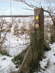
| current | 20:57, 4 March 2011 | | 480 × 640 (149 KB) | commons>GeographBot | == {{int:filedesc}} == {{Information |description={{en|1=Footpath marker beside Boudica's Way This footpath marker is located at the south-eastern edge of Caistor St Edmund chalk pit which can be seen on the other side of the fence. Boudica's Way leads pa |
File usage
There are no pages that use this file.