File:Evercreech Junction Station.jpg
Jump to navigation
Jump to search
No higher resolution available.
Evercreech_Junction_Station.jpg (640 × 391 pixels, file size: 89 KB, MIME type: image/jpeg)
Summary
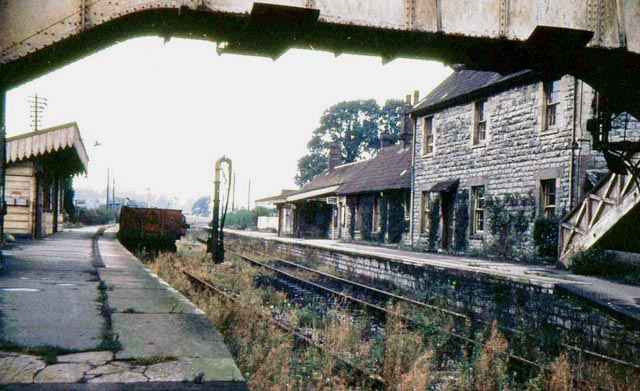
| Description |
English: Evercreech Junction Railway Station Looking towards Bath and Highbridge. The actual junction of the two tracks lies in the middle distance. |
| Date | |
| Source |
This file was derived from: Evercreech Junction Railway Station - geograph.org.uk - 672506.jpg |
| Author | Tudor Williams |
| Permission (Reusing this file) |
Creative Commons Attribution Share-alike license 2.0 |
| Camera location | | View this and other nearby images on: OpenStreetMap |
|---|
_region:GB-EAW_heading:337.00&language=en)
| Object location | | View this and other nearby images on: OpenStreetMap |
|---|
_region:GB-EAW_heading:337.00&language=en)
| This is a retouched picture, which means that it has been digitally altered from its original version. Modifications: Colour correction. Modifications made by DBailey635. The original can be found here: https://www.geograph.org.uk/photo/672506 geograph.org.uk.
|
Licensing
This file is licensed under the Creative Commons Attribution-Share Alike 2.0 Generic license.
Attribution: Tudor Williams
- You are free:
- to share – to copy, distribute and transmit the work
- to remix – to adapt the work
- Under the following conditions:
- attribution – You must give appropriate credit, provide a link to the license, and indicate if changes were made. You may do so in any reasonable manner, but not in any way that suggests the licensor endorses you or your use.
- share alike – If you remix, transform, or build upon the material, you must distribute your contributions under the same or compatible license as the original.
File history
Click on a date/time to view the file as it appeared at that time.
| Date/Time | Thumbnail | Dimensions | User | Comment | |
|---|---|---|---|---|---|
| current | 12:52, 29 March 2010 | | 640 × 391 (89 KB) | commons>DBailey635 | Colour correction |
File usage
There are no pages that use this file.