File:East Midlands Gateway – the rail terminal (geograph 6173654).jpg
Jump to navigation
Jump to search

Size of this preview: 800 × 600 pixels. Other resolutions: 320 × 240 pixels | 640 × 480 pixels | 1,024 × 768 pixels | 1,280 × 960 pixels.
Original file (1,280 × 960 pixels, file size: 337 KB, MIME type: image/jpeg)
.jpg)
Summary
| Description |
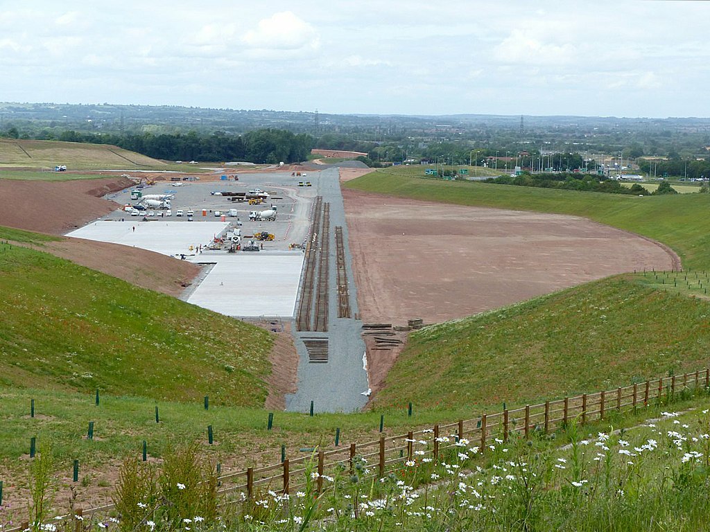
English: East Midlands Gateway – the rail terminal. A huge volume of earth has been removed to create this. The land was previously a more or less a continuous slope from the viewpoint to the woodland at the far end. This is an extensive development for large scale distribution warehousing. It covers around 700 acres with 6 million sq. ft. of warehouse space together with a 50 acre rail container terminal with a connection to the Castle Donington freight line. The latter is capable of handling up to 16 full length container trains a day. When completed there will be 11 large warehouses ranging in size from a 'mere' 225,000 sq. ft. to an enormous 750,000 sq. ft. It is in a key Midlands location close to Nottingham, Leicester and Derby, with excellent communications. It is adjacent to the M1 and A50, the rail connection provides good access to most parts of the UK and East Midlands Airport is a major air freight hub. The warehousing area has been created on a single level terraced out of a sloping hillside, involving an enormous amount of earthmoving, some of which has been used to create screening mounds. The rail terminal ends in a cutting which is around 30 metres deep. As part of the development there was a major reconstruction of the M1 junction 24/24A complex. |
| Date | Taken on 3 June 2019 |
| Source | From geograph.org.uk |
| Author | Alan Murray-Rust |
| Permission (Reusing this file) |
Creative Commons Attribution Share-alike license 2.0 |
| Attribution (required by the license) | Alan Murray-Rust / East Midlands Gateway – the rail terminal / |
| Camera location | | View this and other nearby images on: OpenStreetMap |
|---|
.jpg¶ms=052.834134_N_-001.299931_E_globe:Earth_type:camera_source:geograph-osgb36(SK47262652)_heading:0.00&language=en)
| Object location | | View this and other nearby images on: OpenStreetMap |
|---|
.jpg¶ms=052.836200_N_-001.300050_E_globe:Earth_class:object_type:object_source:geograph-osgb36(SK47252675)_heading:0.00&language=en)
Licensing

|
This image was taken from the Geograph project collection. See this photograph's page on the Geograph website for the photographer's contact details. The copyright on this image is owned by Alan Murray-Rust and is licensed for reuse under the Creative Commons Attribution-ShareAlike 2.0 license.
|
This file is licensed under the Creative Commons Attribution-Share Alike 2.0 Generic license.
Attribution: Alan Murray-Rust
- You are free:
- to share – to copy, distribute and transmit the work
- to remix – to adapt the work
- Under the following conditions:
- attribution – You must give appropriate credit, provide a link to the license, and indicate if changes were made. You may do so in any reasonable manner, but not in any way that suggests the licensor endorses you or your use.
- share alike – If you remix, transform, or build upon the material, you must distribute your contributions under the same or compatible license as the original.
File history
Click on a date/time to view the file as it appeared at that time.
| Date/Time | Thumbnail | Dimensions | User | Comment | |
|---|---|---|---|---|---|
| current | 13:10, 3 February 2022 | | 1,280 × 960 (337 KB) | commons>Chris j wood | == {{int:filedesc}} == {{Information |Description={{en|1=East Midlands Gateway – the rail terminal. A huge volume of earth has been removed to create this. The land was previously a more or less a continuous slope from the viewpoint to the woodland at the far end. This is an extensive development for large scale distribution warehousing. It covers around 700 acres with 6 million sq. ft. of warehouse space together with a 50 acre rail container terminal with a connection to the Castle Doningto... |
File usage
There are no pages that use this file.
.jpg)