File:ESI map.png
Jump to navigation
Jump to search
No higher resolution available.
ESI_map.png (270 × 319 pixels, file size: 56 KB, MIME type: image/png)
File history
Click on a date/time to view the file as it appeared at that time.
| Date/Time | Thumbnail | Dimensions | User | Comment | |
|---|---|---|---|---|---|
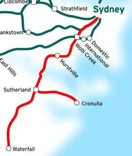
| current | 11:16, 11 August 2007 | | 270 × 319 (56 KB) | commons>Vicer | This is a map of the Eastern Suburbs & Illawarra Line in Sydney, Australia, traced on this public domain map. Original edit by NE2. |
File usage
There are no pages that use this file.