File:EO1 ALI Lamay Island.jpg

From WikiProjectMed
Jump to navigation Jump to search

EO1_ALI_Lamay_Island.jpg(530 × 455 pixels, file size: 227 KB, MIME type: image/jpeg)

This file is from a shared repository and may be used by other projects. The description on its file description page there is shown below.

Description
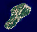
English: The Advanced Land Imager (ALI) on NASA’s Earth Observing-1 satellite captured this image of Lamay Island offshore southwestern Taiwan. This 10-meter resolution false-colored image shows the old airstrip has been occupied by the buildings on the island.
中文:2003年夏天NASA EO-1衛星所拍攝到的琉球嶼, 影像解析度為10公尺。
Date
Source Data source from Earth Observing 1 (EO-1) satellite. Image processed by myself
Author Macos8
Permission
(Reusing this file)
Public domain This file is in the public domain in the United States because it was solely created by NASA. NASA copyright policy states that "NASA material is not protected by copyright unless noted". (See Template:PD-USGov, NASA copyright policy page or JPL Image Use Policy.)
Warnings:
Annotations
InfoField
This image is annotated: View the annotations at Commons

Captions

Add a one-line explanation of what this file represents

Items portrayed in this file

depicts

1 July 2003

File history

Click on a date/time to view the file as it appeared at that time.

Date/TimeThumbnailDimensionsUserComment
current07:35, 17 October 2014Thumbnail for version as of 07:35, 17 October 2014530 × 455 (227 KB)commons>PhilipxdCROP BLACK STRIP

There are no pages that use this file.

Metadata