File:Dollis Brook Viaduct map.png
Jump to navigation
Jump to search
No higher resolution available.
Dollis_Brook_Viaduct_map.png (503 × 301 pixels, file size: 242 KB, MIME type: image/png)
File history
Click on a date/time to view the file as it appeared at that time.
| Date/Time | Thumbnail | Dimensions | User | Comment | |
|---|---|---|---|---|---|
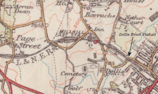
| current | 01:27, 17 April 2010 | | 503 × 301 (242 KB) | commons>File Upload Bot (Magnus Manske) | {{BotMoveToCommons|en.wikipedia|year={{subst:CURRENTYEAR}}|month={{subst:CURRENTMONTHNAME}}|day={{subst:CURRENTDAY}}}} {{Information |Description={{en|1934 Ordnance Survey map marked-up to show the location of the Dollis Brook Viaduct<br/> [[:en:Category |
File usage
There are no pages that use this file.