File:Doaks-Stand.png
Jump to navigation
Jump to search

Size of this preview: 794 × 599 pixels. Other resolutions: 318 × 240 pixels | 636 × 480 pixels | 1,018 × 768 pixels | 1,280 × 966 pixels | 2,272 × 1,715 pixels.
Original file (2,272 × 1,715 pixels, file size: 40 KB, MIME type: image/png)
Summary
| Description |
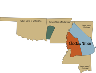
English: Map of U.S. states Arkansas, Mississippi, and Oklahoma in relation to Choctaw land ceded to the U.S. According to the Treaty of Doak's Stand (1820) the area in orange was ceded to the United States, and the area in green was ceded to the Choctaw nation. |
| Date | |
| Source | Own work |
| Author | Rob (talk) |
Licensing
| I, the copyright holder of this work, release this work into the public domain. This applies worldwide. In some countries this may not be legally possible; if so: I grant anyone the right to use this work for any purpose, without any conditions, unless such conditions are required by law. |
File history
Click on a date/time to view the file as it appeared at that time.
| Date/Time | Thumbnail | Dimensions | User | Comment | |
|---|---|---|---|---|---|
| current | 20:48, 24 April 2008 | | 2,272 × 1,715 (40 KB) | commons>Robfergusonjr | Author: Rob Ferguson. |
File usage
There are no pages that use this file.