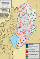
File:Demographic map of the Golan Heights and Syrian localities depopulated during and after the 1967 War - Legend.png
Jump to navigation
Jump to search

Size of this preview: 407 × 600 pixels. Other resolutions: 163 × 240 pixels | 325 × 480 pixels | 521 × 768 pixels | 1,255 × 1,850 pixels.
Original file (1,255 × 1,850 pixels, file size: 169 KB, MIME type: image/png)
File history
Click on a date/time to view the file as it appeared at that time.
| Date/Time | Thumbnail | Dimensions | User | Comment | |
|---|---|---|---|---|---|
| current | 17:31, 6 June 2022 | | 1,255 × 1,850 (169 KB) | commons>BasilLeaf | Uploaded own work with UploadWizard |
File usage
There are no pages that use this file.