File:Crawley Neighbourhoods (Northgate).png
Jump to navigation
Jump to search
No higher resolution available.
Crawley_Neighbourhoods_(Northgate).png (260 × 277 pixels, file size: 4 KB, MIME type: image/png)
.png)
File history
Click on a date/time to view the file as it appeared at that time.
| Date/Time | Thumbnail | Dimensions | User | Comment | |
|---|---|---|---|---|---|
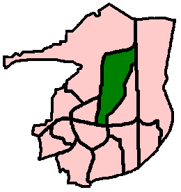
| current | 20:44, 11 March 2020 | | 260 × 277 (4 KB) | commons>Hassocks5489 | == {{int:filedesc}} == {{Information |Description={{en|1=PNG diagram of the Crawley Borough area (in West Sussex, England), showing the 13 residential neighbourhoods and highlighting Northgate in pine green. (Each neighbourhood was allocated a colour when it was built, which together with its name is used on street name signs. Pine green is Northgate's official colour.)}} |Source={{Own}} |Author=Hassocks5489 |Date=2020-03-11 |Permission= |other_versions= }} == {{int:l... |
File usage
There are no pages that use this file.
.png)