File:Communes of Rwanda.svg

Original file (SVG file, nominally 1,600 × 1,400 pixels, file size: 689 KB)
Summary
| Description |
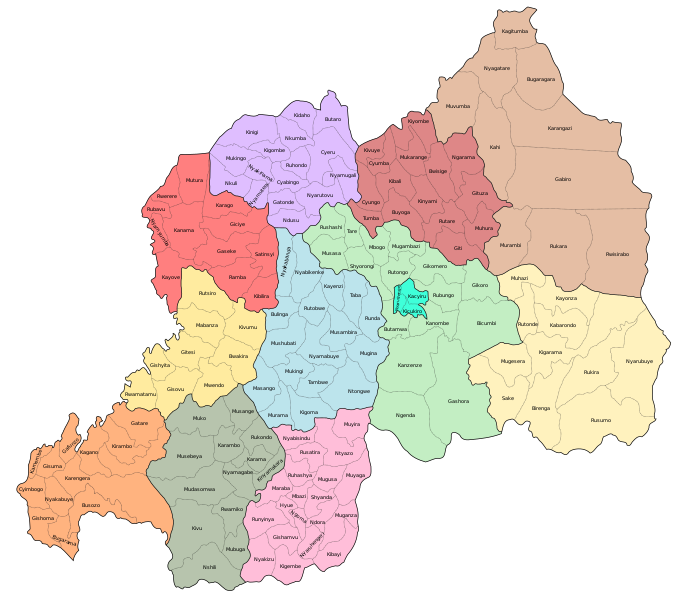
English: Communes of Rwanda after the formation of Umutara prefecture in 1996.
Good maps of the communes were hard to come by online, but some maps are available from the MICT website by querying their "Judicial Records and Archives Database". I mostly used the map in the exhibit titled "BIZIMUNGU ET AL - MAP OF RWANDA [ADMINISTRATIVE AND ROAD MAPS]" (Rec. Number 11611). Also interesting is "KAREMERA ET AL - RWANDA - ADMINISTRATIVE AND ROAD MAP" (Rec. Number 13404). There are also available more detailed maps of some prefectures (usually as part of larger pdf files) which I have made use of where the commune borders are tricky, for example over the Nyungwe forest. This map may contain some minor mistakes. For example, I am not totally sure about the Nyagatare-Muvumba border.
|
| Date | |
| Source | Own work |
| Author | Mattias Ugelvik |
| Other versions |
 |
Licensing
- You are free:
- to share – to copy, distribute and transmit the work
- to remix – to adapt the work
- Under the following conditions:
- attribution – You must give appropriate credit, provide a link to the license, and indicate if changes were made. You may do so in any reasonable manner, but not in any way that suggests the licensor endorses you or your use.
- share alike – If you remix, transform, or build upon the material, you must distribute your contributions under the same or compatible license as the original.
File history
Click on a date/time to view the file as it appeared at that time.
| Date/Time | Thumbnail | Dimensions | User | Comment | |
|---|---|---|---|---|---|
| current | 00:53, 8 January 2021 | | 1,600 × 1,400 (689 KB) | commons>Uglemat | c:User:Rillke/bigChunkedUpload.js: Testing to see if less contrast improves rendering |
File usage
There are no pages that use this file.