File:Cheshunt, Theobalds - geograph.org.uk - 552741.jpg
Jump to navigation
Jump to search
No higher resolution available.
Cheshunt,_Theobalds_-_geograph.org.uk_-_552741.jpg (640 × 480 pixels, file size: 121 KB, MIME type: image/jpeg)
Summary
| Description |
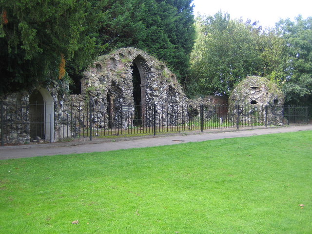
English: Cheshunt: Theobalds These walls and entranceways are one of the few ruins left of the former Theobalds Palace, built by William Cecil, Lord Burghley, in the 1560s. Queen Elizabeth I was a frequent visitor to the Palace. She was succeeded by King James I who stayed at Theobalds in 1603 as a guest of Lord Burghley's son, Robert Cecil, while on his way from Scotland to be crowned in London. King James was so taken with Theobalds that he exchanged it with the Cecils for Hatfield House in 1607. King James I died at Theobalds in 1625, and it remained a royal palace during the reign of King Charles I. However after the accession of Oliver Cromwell and the execution of Charles in 1649, Theobalds was razed to the ground by the Parliamentarians.
Today the remains can be found in Cedars Park. |
| Date | |
| Source | From geograph.org.uk |
| Author | Nigel Cox |
| Attribution (required by the license) | Nigel Cox / Cheshunt: Theobalds / |
| Camera location | | View this and other nearby images on: OpenStreetMap |
|---|
_heading:225.00&language=en)
| Object location | | View this and other nearby images on: OpenStreetMap |
|---|
_heading:225.00&language=en)
Licensing

|
This image was taken from the Geograph project collection. See this photograph's page on the Geograph website for the photographer's contact details. The copyright on this image is owned by Nigel Cox and is licensed for reuse under the Creative Commons Attribution-ShareAlike 2.0 license.
|
This file is licensed under the Creative Commons Attribution-Share Alike 2.0 Generic license.
Attribution: Nigel Cox
- You are free:
- to share – to copy, distribute and transmit the work
- to remix – to adapt the work
- Under the following conditions:
- attribution – You must give appropriate credit, provide a link to the license, and indicate if changes were made. You may do so in any reasonable manner, but not in any way that suggests the licensor endorses you or your use.
- share alike – If you remix, transform, or build upon the material, you must distribute your contributions under the same or compatible license as the original.
File history
Click on a date/time to view the file as it appeared at that time.
| Date/Time | Thumbnail | Dimensions | User | Comment | |
|---|---|---|---|---|---|
| current | 02:33, 6 February 2011 | | 640 × 480 (121 KB) | commons>GeographBot | == {{int:filedesc}} == {{Information |description={{en|1=Cheshunt: Theobalds These walls and entranceways are one of the few ruins left of the former Theobalds Palace, built by William Cecil, Lord Burghley, in the 1560s. Queen Elizabeth I was a frequent v |
File usage
There are no pages that use this file.