File:Charlottetown, Prince Edward Island Location.png
Jump to navigation
Jump to search

Size of this preview: 800 × 484 pixels. Other resolutions: 320 × 193 pixels | 640 × 387 pixels | 1,024 × 619 pixels | 1,280 × 774 pixels | 1,795 × 1,085 pixels.
Original file (1,795 × 1,085 pixels, file size: 183 KB, MIME type: image/png)
La bildo estas kopiita de wikipedia:en. La originala priskribo estas:
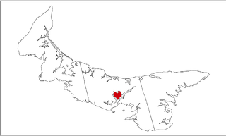
Map highlighting Charlottetown, Prince Edward Island. Map and image created by User:Plasma_east using data courtesy of Geogratis. Released under GFDL.
| This file is licensed under the Creative Commons Attribution-Share Alike 3.0 Unported license. Subject to disclaimers. | ||
| ||
| This licensing tag was added to this file as part of the GFDL licensing update. |

|
Permission is granted to copy, distribute and/or modify this document under the terms of the GNU Free Documentation License, Version 1.2 or any later version published by the Free Software Foundation; with no Invariant Sections, no Front-Cover Texts, and no Back-Cover Texts. A copy of the license is included in the section entitled GNU Free Documentation License. Subject to disclaimers. |
Historia de la dosiero
(del) (cur) 16:29, 10 August 2005 . . Plasma east (Talk | contribs) . . 1795×1085 (187,337 bytes) (Map highlighting Charlottetown, Prince Edward Island. Map and image created by User:Plasma_east using data courtesy of Geogratis. Released under GFDL. { {GFDL}})
File history
Click on a date/time to view the file as it appeared at that time.
| Date/Time | Thumbnail | Dimensions | User | Comment | |
|---|---|---|---|---|---|
| current | 02:47, 2 April 2007 | | 1,795 × 1,085 (183 KB) | commons>Lunofabo | La bildo estas kopiita de [http://en.wikipedia.org wikipedia:en]. La originala priskribo estas: Map highlighting Charlottetown, Prince Edward Island. Map and image created by User:Plasma_east using data courtesy of [http://geogratis.cgdi.gc.ca Geogratis] |
File usage
There are no pages that use this file.