File:Carte des Hammadides et leurs voisins v.1050 (English cropped).png
Jump to navigation
Jump to search

Size of this preview: 800 × 450 pixels. Other resolutions: 320 × 180 pixels | 640 × 360 pixels | 1,024 × 576 pixels | 1,280 × 720 pixels | 2,560 × 1,441 pixels | 4,503 × 2,534 pixels.
Original file (4,503 × 2,534 pixels, file size: 1,019 KB, MIME type: image/png)
.png)
Summary
| Description |
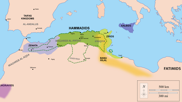
English: Map of the Hammadid realm (green) and their neighbours, with extended or maximal territories in dotted line (controlled in different periods, mostly during the reign of al-Nasir).
The original file cited these as sources:
My own addendum to these sources:
|
| Date | |
| Source | Wiki Commons (Carte des Hammadides et leurs voisins v.1050.png) |
| Author | (minor edits by R Prazeres) |
Licensing
This file is licensed under the Creative Commons Attribution-Share Alike 4.0 International license.
- You are free:
- to share – to copy, distribute and transmit the work
- to remix – to adapt the work
- Under the following conditions:
- attribution – You must give appropriate credit, provide a link to the license, and indicate if changes were made. You may do so in any reasonable manner, but not in any way that suggests the licensor endorses you or your use.
- share alike – If you remix, transform, or build upon the material, you must distribute your contributions under the same or compatible license as the original.
File history
Click on a date/time to view the file as it appeared at that time.
| Date/Time | Thumbnail | Dimensions | User | Comment | |
|---|---|---|---|---|---|
| current | 18:09, 12 April 2022 | | 4,503 × 2,534 (1,019 KB) | commons>R Prazeres | Fixed unintended white margins |
File usage
There are no pages that use this file.
.png)