File:Cape Verde hurricane track.jpg
Jump to navigation
Jump to search

Size of this preview: 800 × 296 pixels. Other resolutions: 320 × 118 pixels | 640 × 237 pixels | 1,024 × 379 pixels | 2,550 × 944 pixels.
Original file (2,550 × 944 pixels, file size: 317 KB, MIME type: image/jpeg)
File history
Click on a date/time to view the file as it appeared at that time.
| Date/Time | Thumbnail | Dimensions | User | Comment | |
|---|---|---|---|---|---|
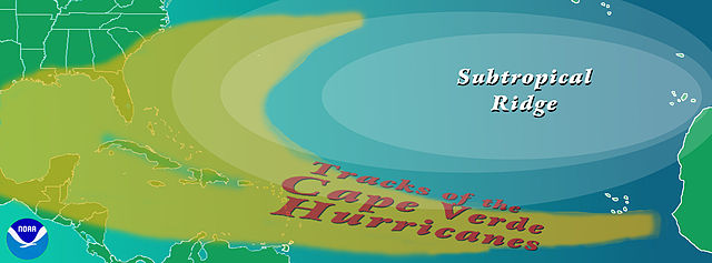
| current | 17:40, 21 August 2008 | 2,550 × 944 (317 KB) | commons>OhanaUnited | {{Information |Description={{en|Graphic showing the typical track of a en:Cape Verde-type hurricane. The tracks begin south of en:Cape Verde in the eastern en:Atlantic Ocean. ==Copyright status== The NOAA emblem is the property of the [[:e |
File usage
There are no pages that use this file.