File:Bundesarchiv Bild 183-19820-0001, Dresden, Technische Hochschule, Observatorium, Beier-Bau.jpg
Jump to navigation
Jump to search
No higher resolution available.
Bundesarchiv_Bild_183-19820-0001,_Dresden,_Technische_Hochschule,_Observatorium,_Beier-Bau.jpg (756 × 552 pixels, file size: 71 KB, MIME type: image/jpeg)
Summary
| Photographer |
Höhne, Erich; Pohl, Erich |
||||||||||||||||||||||||||
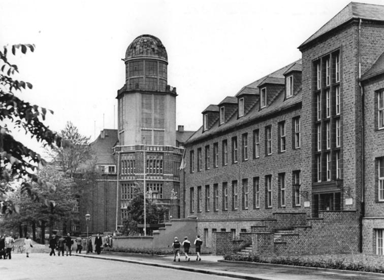
| Original caption |
For documentary purposes the German Federal Archive often retained the original image captions, which may be erroneous, biased, obsolete or politically extreme. Dresden, Technische Hochschule, Observatorium, Beier-Bau
Zentralbild Höhne-Pohl 2.6.1953 125 Jahre Technische Hochschule Dresden Vom 4. bis 7.6.1953 werden die Jubiläumsfeierlichkeiten zur 125. Wiederkehr des Gründungstages der Technischen Hochschule Dresden stattfinden. U.Bz.: Blick auf das Observatorium - das Wahrzeichen der Hochschule - und das wiedererichtete Gebäude für Bauingenieure mit dem Beier-Bau. |
||||||||||||||||||||||||||
| Depicted place | Dresden | ||||||||||||||||||||||||||
| Date | 2 June 1953 | ||||||||||||||||||||||||||
| Collection |
|
||||||||||||||||||||||||||
| Current location |
Allgemeiner Deutscher Nachrichtendienst - Zentralbild (Bild 183) |
||||||||||||||||||||||||||
| Accession number | |||||||||||||||||||||||||||
| Source |
|
||||||||||||||||||||||||||

Licensing
This file is licensed under the Creative Commons Attribution-Share Alike 3.0 Germany license.
Attribution: Bundesarchiv, Bild 183-19820-0001 / CC-BY-SA 3.0
- You are free:
- to share – to copy, distribute and transmit the work
- to remix – to adapt the work
- Under the following conditions:
- attribution – You must give appropriate credit, provide a link to the license, and indicate if changes were made. You may do so in any reasonable manner, but not in any way that suggests the licensor endorses you or your use.
- share alike – If you remix, transform, or build upon the material, you must distribute your contributions under the same or compatible license as the original.

| Camera location | | View this and other nearby images on: OpenStreetMap |
|---|
| Object location | | View this and other nearby images on: OpenStreetMap |
|---|
File history
Click on a date/time to view the file as it appeared at that time.
| Date/Time | Thumbnail | Dimensions | User | Comment | |
|---|---|---|---|---|---|
| current | 16:12, 7 January 2020 | | 756 × 552 (71 KB) | commons>Xgeorg | Cropped 6 % horizontally, 6 % vertically using CropTool with lossless mode. |
File usage
There are no pages that use this file.