File:British 7th Century.png
Jump to navigation
Jump to search

Size of this preview: 454 × 599 pixels. Other resolutions: 182 × 240 pixels | 364 × 480 pixels | 1,000 × 1,320 pixels.
Original file (1,000 × 1,320 pixels, file size: 1.59 MB, MIME type: image/png)
File history
Click on a date/time to view the file as it appeared at that time.
| Date/Time | Thumbnail | Dimensions | User | Comment | |
|---|---|---|---|---|---|
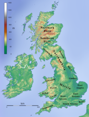
| current | 22:28, 6 January 2009 | | 1,000 × 1,320 (1.59 MB) | commons>Kmusser | {{Information |Description=Map depicting the British Islands during the 7th century. |Source=Own work created by combining File:Topographic Map of the UK - Blank.png and en:File:British 7C kingdoms with Bernicia and Deira.gif. |Date=January 6, 2 |
File usage
There are no pages that use this file.