File:Brasilodon localities.png
Jump to navigation
Jump to search

Size of this preview: 800 × 284 pixels. Other resolutions: 320 × 114 pixels | 640 × 227 pixels | 1,024 × 364 pixels | 2,252 × 800 pixels.
Original file (2,252 × 800 pixels, file size: 461 KB, MIME type: image/png)
Summary
| Description |
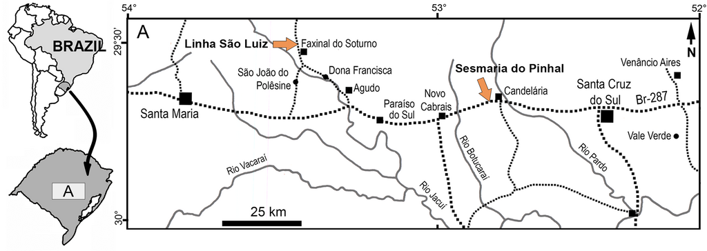
English: Localities with Brasilodon quadrangularis.
Location map showing the Linha São Luis and Sesmaria do Pinhal sites, in Rio Grande do Sul state, southern Brazil. |
| Date | |
| Source | https://journals.plos.org/plosone/article?id=10.1371/journal.pone.0216672 |
| Author | Morgan L. Guignard, Agustin G. Martinelli, Marina B. Soares |
Licensing
This file is licensed under the Creative Commons Attribution 4.0 International license.
- You are free:
- to share – to copy, distribute and transmit the work
- to remix – to adapt the work
- Under the following conditions:
- attribution – You must give appropriate credit, provide a link to the license, and indicate if changes were made. You may do so in any reasonable manner, but not in any way that suggests the licensor endorses you or your use.
File history
Click on a date/time to view the file as it appeared at that time.
| Date/Time | Thumbnail | Dimensions | User | Comment | |
|---|---|---|---|---|---|
| current | 13:52, 25 September 2022 | 2,252 × 800 (461 KB) | commons>Trilletrollet | Uploaded a work by Morgan L. Guignard, Agustin G. Martinelli, Marina B. Soares from https://journals.plos.org/plosone/article?id=10.1371/journal.pone.0216672 with UploadWizard |
File usage
There are no pages that use this file.