File:Blake River Megacaldera Complex map.jpg
Jump to navigation
Jump to search

Size of this preview: 800 × 478 pixels. Other resolutions: 320 × 191 pixels | 640 × 382 pixels | 906 × 541 pixels.
Original file (906 × 541 pixels, file size: 229 KB, MIME type: image/jpeg)
File history
Click on a date/time to view the file as it appeared at that time.
| Date/Time | Thumbnail | Dimensions | User | Comment | |
|---|---|---|---|---|---|
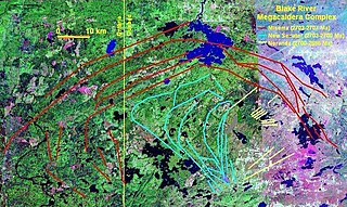
| current | 01:22, 14 October 2008 | | 906 × 541 (229 KB) | commons>Black Tusk | {{Information |Description={{en|1=Map of the Blake River Megacaldera Complex.}} |Source=NASA World Wind |Author=NASA/Black Tusk |Date=October 13, 2008 |Permission=NASA, public domain |other_versions= }} <!--{{ImageUpload|full}}--> |
File usage
There are no pages that use this file.