File:Banat Josephinische Landaufnahme pg193.jpg
Jump to navigation
Jump to search

Size of this preview: 800 × 498 pixels. Other resolutions: 320 × 199 pixels | 640 × 399 pixels | 1,024 × 638 pixels | 1,280 × 797 pixels | 2,560 × 1,594 pixels | 9,213 × 5,738 pixels.
Original file (9,213 × 5,738 pixels, file size: 34.87 MB, MIME type: image/jpeg)
| Warning | The original file is very high-resolution. It might not load properly or could cause your browser to freeze when opened at full size. |
|---|
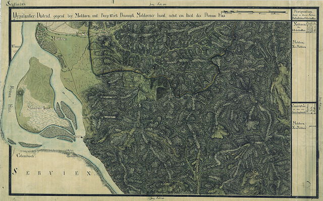
| Name shown on the map Nume din hartă |
Administrative unit Unitate administrativă |
Romanian name Numele românesc |
Hungarian name Numele unguresc |
German name Numele german |
Serbian name Numele sârbesc |
Country today Ţara de astăzi |
|---|---|---|---|---|---|---|
| Moldova | Oláh-illír bánsági ezred (Román-illír bánsági kerület) | Moldova Veche | Ómoldova | Alt-Moldowa | Стара Молдава | Romania |
| Neu Moldova vel Bosniak | Krassó megye | Moldova Nouă | Újmoldova, Moldovabánya, Bosnyákmoldova, Bosnyák | Neu-Moldowa, Bergwerk-Neumoldowa | Нова Молдава | Románia |
Summary
| Description |
Deutsch: Das Banat in: Josephinische Landesaufnahme, 1769-72. Josephinische Landaufnahme pg193 English: The Banat region in the cadastral maps: Josephinische Landesaufnahme, 1769-72. Josephinische Landaufnahme pg193 |
||||
| Date | between 1769 and 1772 | ||||
| Source | Österreichisches Staatsarchiv, Kriegsarchiv | ||||
| Author | Historische Militärkarte der österreichisch-ungarischen Monarchie | ||||
| Permission (Reusing this file) |
|
||||
Clickable map of the Banat region

File history
Click on a date/time to view the file as it appeared at that time.
| Date/Time | Thumbnail | Dimensions | User | Comment | |
|---|---|---|---|---|---|
| current | 08:02, 5 January 2010 | | 9,213 × 5,738 (34.87 MB) | commons>Asybaris01 | {{Information |Description={{ro|1=Banat Josephinische Landaufnahme pg193}} |Source={{own}} |Author=Asybaris01 |Date=1769-72 |Permission= |other_versions= }} Category:Josephinische Landaufnahme |
File usage
There are no pages that use this file.