File:Alternative alignments for the Red Line Northwest Extension.jpg
Jump to navigation
Jump to search

Size of this preview: 800 × 493 pixels. Other resolutions: 320 × 197 pixels | 640 × 395 pixels | 1,024 × 632 pixels | 1,280 × 789 pixels | 2,560 × 1,579 pixels | 5,018 × 3,095 pixels.
Original file (5,018 × 3,095 pixels, file size: 3.22 MB, MIME type: image/jpeg)
File history
Click on a date/time to view the file as it appeared at that time.
| Date/Time | Thumbnail | Dimensions | User | Comment | |
|---|---|---|---|---|---|
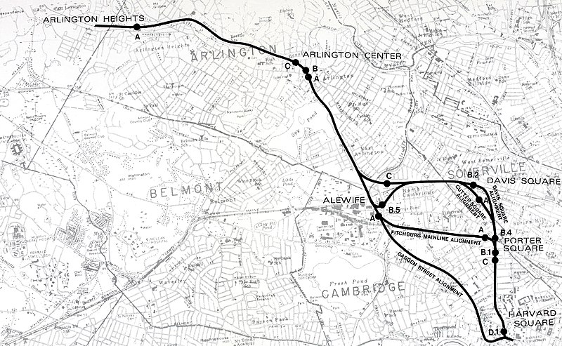
| current | 01:15, 6 August 2020 | | 5,018 × 3,095 (3.22 MB) | commons>Pi.1415926535 | {{Information |description ={{en|1=Map of the alternative alternatives for the Red Line Northwest Extension, published in the 1977 Environmental Impact Statement. The route chosen was via Davis Square, with station locations D-1 (Harvard), B-4 (Porter), B-2 (Davis), B-5 (Alewife), A (Arlington), and A (Arlington Heights). The Arlington portion was cancelled; only the portion to Alewife plus a short section of tunnel towards Arlington for tail tracks was actually built.}} |date =197... |
File usage
There are no pages that use this file.