File:2020 US presidential margins by county.svg
Jump to navigation
Jump to search

Size of this PNG preview of this SVG file: 600 × 352 pixels. Other resolutions: 320 × 188 pixels | 640 × 375 pixels | 1,024 × 601 pixels | 1,280 × 751 pixels | 2,560 × 1,502 pixels.
Original file (SVG file, nominally 600 × 352 pixels, file size: 1.12 MB)
Summary
| Description |
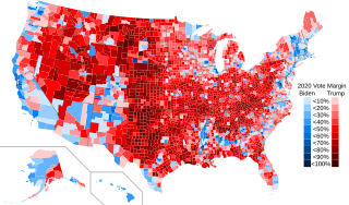
English: Counties and equivalents shaded by vote margin in the 2020 United States presidential election (percentage of votes for winning candidate minus percentage of votes for losing candidate). For all states except Alaska, data sourced from Dave Leip's Atlas of U.S. Presidential Elections. Data for Alaska is from RRH Elections. |
| Date | |
| Source | File:USA Counties with names.svg |
| Author | Crossover1370 |
Licensing
I, the copyright holder of this work, hereby publish it under the following license:
This file is licensed under the Creative Commons Attribution-Share Alike 4.0 International license.
- You are free:
- to share – to copy, distribute and transmit the work
- to remix – to adapt the work
- Under the following conditions:
- attribution – You must give appropriate credit, provide a link to the license, and indicate if changes were made. You may do so in any reasonable manner, but not in any way that suggests the licensor endorses you or your use.
- share alike – If you remix, transform, or build upon the material, you must distribute your contributions under the same or compatible license as the original.
File history
Click on a date/time to view the file as it appeared at that time.
| Date/Time | Thumbnail | Dimensions | User | Comment | |
|---|---|---|---|---|---|
| current | 04:49, 24 February 2022 | | 600 × 352 (1.12 MB) | commons>Crossover1370 | minor changes to legend |
File usage
There are no pages that use this file.