File:1852 Middlesex Canal (Massachusetts) map.jpg
Jump to navigation
Jump to search

Size of this preview: 411 × 599 pixels. Other resolutions: 165 × 240 pixels | 329 × 480 pixels | 527 × 768 pixels | 703 × 1,024 pixels | 2,310 × 3,365 pixels.
Original file (2,310 × 3,365 pixels, file size: 9.03 MB, MIME type: image/jpeg)
_map.jpg)
File history
Click on a date/time to view the file as it appeared at that time.
| Date/Time | Thumbnail | Dimensions | User | Comment | |
|---|---|---|---|---|---|
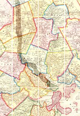
| current | 16:49, 14 January 2007 | | 2,310 × 3,365 (9.03 MB) | commons>Daderot | {{Information |Description=Map of the lower stretch of the Middlesex Canal, north of Boston, Massachusetts, 1852. This map was made about the time the canal was abandoned, some 50 years after its construction was completed. |Source=Map entitled "Boston an |
File usage
There are no pages that use this file.
_map.jpg)