File:1815 tambora explosion.png
Jump to navigation
Jump to search

Size of this preview: 800 × 358 pixels. Other resolutions: 320 × 143 pixels | 640 × 286 pixels | 1,200 × 537 pixels.
Original file (1,200 × 537 pixels, file size: 720 KB, MIME type: image/png)
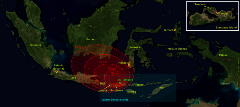
| Description | The 1815 Mount Tambora eruption. The red areas are maps of the thickness of volcanic ashfall. | ||||||||
| Source | The base map was taken from NASA picture Image:Indonesia_BMNG.png and the isopach maps were traced from Oppenheimer (2003).[1] | ||||||||
| Author | myself | ||||||||
| Permission (Reusing this file) |
|
||||||||
| Other versions |
Deutsch: Von diesem Bild existieren die folgenden Bildbearbeitungen aus der Bilderwerkstatt: English: Retouched versions of this picture from the german Graphic Lab:
|

References
- ↑ Oppenheimer, Clive (2003). "Climatic, environmental and human consequences of the largest known historic eruption: Tambora volcano (Indonesia) 1815". Progress in Physical Geography 27 (2): 230-259.
File history
Click on a date/time to view the file as it appeared at that time.
| Date/Time | Thumbnail | Dimensions | User | Comment | |
|---|---|---|---|---|---|
| current | 13:14, 11 October 2006 | | 1,200 × 537 (720 KB) | commons>Indon~commonswiki | {{Information |Description= The 1815 Mount Tambora eruption. The red areas are maps of the thickness of vulcanic ashfall. |Source=The base map was taken from NASA picture Image:Indonesia_BMNG.png and the isopach maps were traced |
File usage
There are no pages that use this file.