File:גלישת עננים למכתש רמון.jpg
Jump to navigation
Jump to search

Size of this preview: 800 × 533 pixels. Other resolutions: 320 × 213 pixels | 640 × 427 pixels | 1,024 × 683 pixels | 1,280 × 853 pixels | 2,560 × 1,707 pixels | 5,417 × 3,611 pixels.
Original file (5,417 × 3,611 pixels, file size: 8.42 MB, MIME type: image/jpeg)
Summary
| Description |
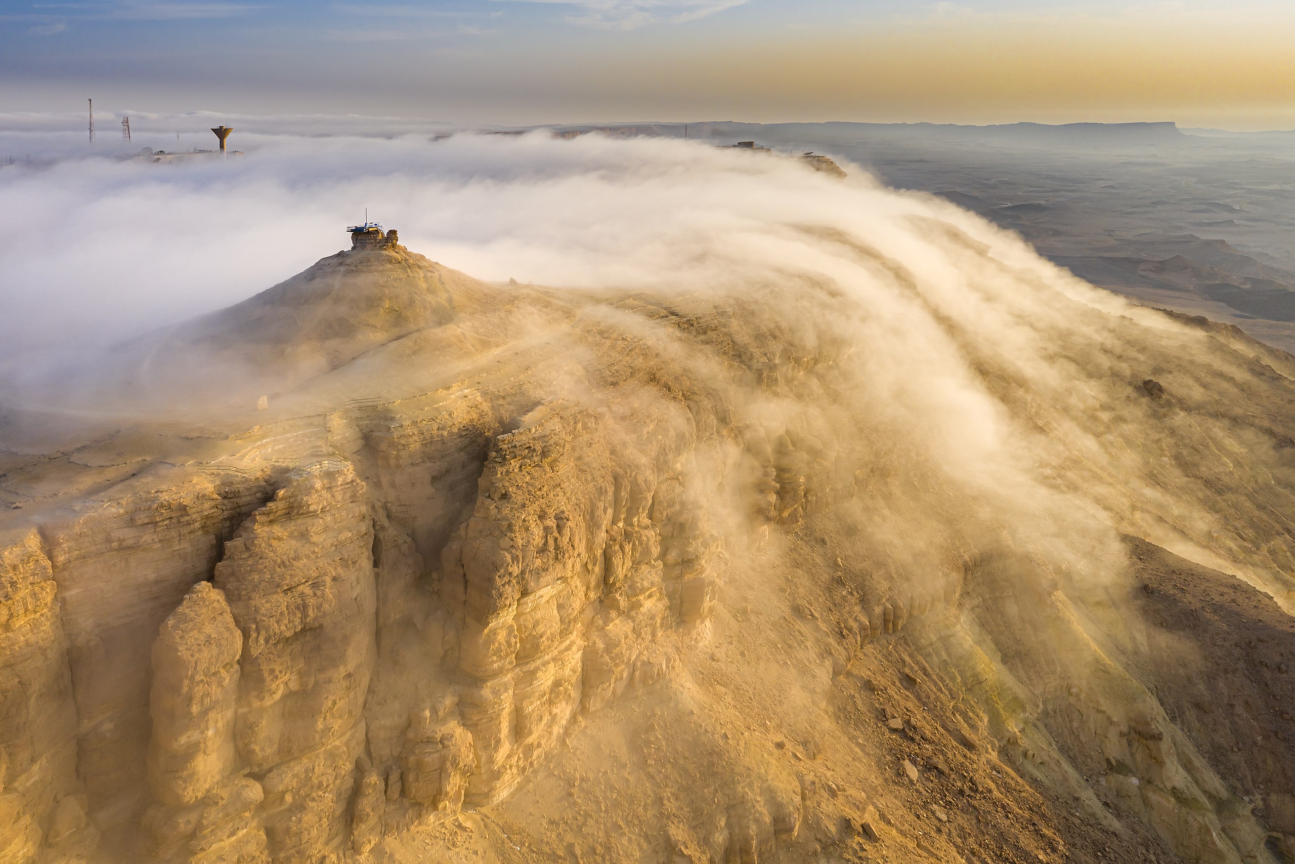
עברית: מכתש רמון הוא המכתש האירוזי הגדול בעולם. הוא מצוי בישראל ומהווה אחד מחמשת המכתשים שבנגב. נופו של מכתש רמון הוא ייחודי. על קצה המכתש מצויה העיירה מצפה רמון.
English: Cloud gliding (advection fog) in Makhtesh Ramon, world's largest "erosion cirque" (steephead valley or box canyons), in Israel. Taken with a drone camera.
Español: Niebla de advección llevada por un viento catabático en Makhtesh Ramon, un gran "circo de erosión" (cañón) en el desierto del Néguev, Israel. Foto tomada con un dron.
Українська: Хмарне ковзання (адвективний туман) у Махтеш-Рамон, найбільшому у світі «ерозійному цирку» (крута долина або каньйон), в Ізраїлі. Знято камерою дрона.
|
||
| Date | |||
| Source | Own work | ||
| Author | Giladtop |
| Camera location | | View this and other nearby images on: OpenStreetMap |
|---|
Assessment
|
This image was selected as picture of the day on Wikimedia Commons for 23 March 2023. It was captioned as follows: English: Cloud gliding (advection fog) in Makhtesh Ramon, world's largest "erosion cirque" (steephead valley or box canyons), in Israel. Taken with a drone camera. Other languages:
Čeština: Přesun oblaků mlhy v snížené oblasti Machteš Ramon, největším světovém erozním "cirkusu" v okolí této suotěsky v Izraeli na záběru z dronu. Deutsch: Wolkengleiten: Advektionsnebel in Machtesch Ramon, dem weltweit größten Erosionskrater in der Wüste Negev, Israel. English: Cloud gliding (advection fog) in Makhtesh Ramon, world's largest "erosion cirque" (steephead valley or box canyons), in Israel. Taken with a drone camera. Español: Niebla de advección llevada por un viento catabático en Makhtesh Ramon, un gran "circo de erosión" (cañón) en el desierto del Néguev, Israel. Foto tomada con un dron. Français : Du brouillard d'advection formé au-dessus du Makhtesh Ramon, cirque d'érosion karstique du désert du Neguev en Israël. Português: Nevoeiro advectivo levado por um vento catabático em Makhtesh Ramon, um grande “circo de erosão” (desfiladeiro) no deserto do Neguev, Israel. Foto tirada com um drone. Slovenščina: Drsenje oblakov (advekcijska megla) v Makteš Ramonu, največji »erozijski krnici« (zatrepni dolini al zaprtem kanjonu) v Izraelu. Posneto z dronsko kamero. Македонски: Насобирање на адвективна магла на Махтеш Рамон во Израел, најголемиот ерозивен цирк на светот. Русский: Облачное скольжение (адвективный туман) в Махтеш-Рамоне — крупнейшем в мире «эрозионном цирке» (крутой долине или коробчатом каньоне) в Израиле. Снято камерой дрона. Українська: Хмарне ковзання (адвективний туман) у Махтеш-Рамон, найбільшому у світі «ерозійному цирку» (крута долина або каньйон), в Ізраїлі. Знято камерою дрона. |

|
This image was awarded with the 8th prize worldwide in Wiki Loves Monuments 2020 Other languages:
|

|
This image was uploaded as part of Wiki Loves Monuments 2020.
|
 |
Licensing
I, the copyright holder of this work, hereby publish it under the following license:
This file is licensed under the Creative Commons Attribution-Share Alike 4.0 International license.
- You are free:
- to share – to copy, distribute and transmit the work
- to remix – to adapt the work
- Under the following conditions:
- attribution – You must give appropriate credit, provide a link to the license, and indicate if changes were made. You may do so in any reasonable manner, but not in any way that suggests the licensor endorses you or your use.
- share alike – If you remix, transform, or build upon the material, you must distribute your contributions under the same or compatible license as the original.
File history
Click on a date/time to view the file as it appeared at that time.
| Date/Time | Thumbnail | Dimensions | User | Comment | |
|---|---|---|---|---|---|
| current | 08:30, 12 October 2020 | | 5,417 × 3,611 (8.42 MB) | commons>Giladtop | Uploaded own work with UploadWizard |
File usage
There are no pages that use this file.