Talk:Hurricane Dennis/workpage
 Dennis prior to peak intensity approaching the Florida Panhandle on July 10 | |
| Meteorological history | |
|---|---|
| Formed | July 4, 2005 |
| Remnant low | July 13, 2005 |
| Dissipated | July 18, 2005 |
| Category 4 major hurricane | |
| 1-minute sustained (SSHWS/NWS) | |
| Highest winds | 150 mph (240 km/h) |
| Lowest pressure | 930 mbar (hPa); 27.46 inHg |
| Overall effects | |
| Fatalities | 88 |
| Damage | $3.98 billion (2005 USD) |
| Areas affected |
|
Part of the 2005 Atlantic hurricane season | |
| History
Effects Other wikis | |
Hurricane Dennis was an early-forming major hurricane in the Caribbean and Gulf of Mexico during the record-breaking 2005 Atlantic hurricane season. Dennis was the fourth named storm, second hurricane, and first major hurricane of the season. Forming in July, the hurricane became the strongest Atlantic hurricane ever to form before August at the time, a title it held for only six days before being surpassed by Hurricane Emily. It also became the second wettest tropical cyclone in the state of Kentucky only behind the 1960 Texas tropical storm.
Dennis made landfall in Cuba twice as a Category 4 hurricane on the Saffir–Simpson scale and made landfall on the United States' Florida Panhandle as a Category 3 storm, coming less than a year after the devastating Hurricane Ivan. Dennis killed 88 people in total and was responsible for $3.98 billion (2005 USD) in damages, of which $2.5 billion (2005 USD) occurred in the United States.
Meteorological history

Tropical storm (39–73 mph, 63–118 km/h)
Category 1 (74–95 mph, 119–153 km/h)
Category 2 (96–110 mph, 154–177 km/h)
Category 3 (111–129 mph, 178–208 km/h)
Category 4 (130–156 mph, 209–251 km/h)
Category 5 (≥157 mph, ≥252 km/h)
Unknown
The tropical wave that became Dennis was identified by the National Hurricane Center on June 26, 2005, well inland over Africa.[1][2][3] It later emerged over the Atlantic Ocean on June 29 and moved quickly to the west.[1] Dry conditions over the Sahara initially inhibited development,[4][5] though the wave found more favorable conditions and intensified into a tropical depression on July 4 while nearing the Windward Islands.[1] The depression soon crossed the island country of Grenada before entering the Caribbean, where increasingly favorable environmental factors, such as low wind shear and high sea surface temperatures, fueled intensification.[6][7][8] Turning west-northwest, the system achieved tropical storm status on July 5 and hurricane status the following day.[1] Formation of a well-defined eye and central dense overcast signaled Dennis's intensification into a major hurricane on July 7.[1][9] The hurricane subsequently traversed the Jamaica Channel, bringing deadly floods to both Jamaica and Haiti.[1]
The powerful storm soon struck Granma Province, Cuba, as a Category 4 hurricane early on July 8; violent winds battered the province and caused extensive damage. Briefly weakening due to interaction with land, Dennis quickly regained its strength. Paralleling the southwestern coast of Cuba, Dennis reached its peak winds of 150 miles per hour (240 km/h). However, it soon weakened to winds of 140 mph (230 km/h) later that day as a result of an eyewall replacement cycle before making a second landfall in the country, this time in Matanzas Province.[1] Interaction with the mountains of Cuba caused significant weakening;[10] however, once Dennis emerged over the Gulf of Mexico on July 9, it quickly reorganized in favorable conditions. The hurricane reached Category 4 strength for the third time on July 10 as it approached Florida, attaining its lowest barometric pressure of 930 mbar (hPa; 27.46 inHg).[1] This ranked Dennis as the strongest hurricane in the Atlantic basin to form before August; however, this record was broken just six days later by Hurricane Emily, which surpassed Dennis and attained Category 5 status.[11][12] Weakening ensued as the hurricane approached the Florida Panhandle, the storm ultimately making landfall over Santa Rosa Island on July 10 as a Category 3. Weakening continued as the cyclone moved further inland, and the storm quickly lost tropical cyclone status. Dennis' remnant circulation remained, however, traversing the Mississippi River Valley and Ohio River Valley before finally dissipating over Ontario on July 18.[1]
Preparations
Within hours of Dennis becoming a tropical storm on July 5, the Government of Haiti issued a tropical storm watch for areas between Port-au-Prince and the Haiti–Dominican Republic border. This was soon replaced by a hurricane watch and tropical storm warning spanning the entirety of the nation's Tiburon Peninsula. Owing to the cyclone's proximity, this was further increased to a hurricane warning on July 6.[1] That day, Haiti's National Meteorological Centre (le centre national de météorologie; CNM) advised residents in elevated, exposed locations to evacuate due to the threat of winds in excess of 62 mph (100 km/h).[13] At least 300 people were relocated from Jérémie.[14] They also forecast rainfall accumulations between 3.0 and 4.9 in (75 and 125 mm), leading to the threat of flooding and mudslides. Furthermore, small seagoing craft were urged to remain at port. Local media noted that the nation was particularly vulnerable to disasters with numerous homeless people inhabiting slums around Port-au-Prince in the wake of catastrophic flooding from Hurricane Jeanne in September 2004.[13] At the time of Dennis's arrival, approximately 550,000 people were receiving assistance from the World Food Programme.[15] The Haitian National Red Cross Society mobilized 300 personnel and identified ten potential shelters in the threatened region.[16] At least 700 people utilized these shelters in Les Cayes, Port-Salut, and the Grand'Anse.[17] The Pan American Disaster Response Unit branch of the International Federation of Red Cross And Red Crescent Societies (IFRC) was equipped with supplies for 10,000 people and prepared to deploy.[16]
Late on July 5, the Government of Jamaica issued a hurricane watch for the nation as Dennis intensified over the eastern Caribbean. This was upgraded to a hurricane warning early on July 6.[1] Following the issuance of the hurricane warning, Jamaica's National Emergency Operations Center and Parish Emergency Operations Center were activated.[18] At the behest of Jamaica's Office of Disaster Preparedness and Emergency Management, the Caribbean Disaster Emergency Management Agency allocated resources to assist the nation following the passage of Dennis.[19] The Jamaican Red Cross also notified its branches of the storm,[20] placing personnel and volunteers on standby on July 7.[21] The Jamaica Defence Force Coast Guard assisted with evacuations of Pedro Bank and Morant Cays. Shelters prepped for opening by the evening of July 6 and Norman Manley International Airport ceased operations at 04:00 UTC (11:00 p.m. local time) and Sangster International Airport following soon thereafter.[18][22] By July 7, 30 shelters opened across five parishes,[23] with at least 793 people using their services.[24] Some officials complained that residents refused to evacuate.[25] However, as the storm impacted the island this number dramatically increased to 6,000 people with shelters open in all parishes.[26] Approximately J$25 million (US$405,000) was made available for relief operations through the nation's Disaster Mitigation Programme. An additional J$20 million (US$324,000) was allocated for clearing drains in preparation for heavy rain.[27]
In preparation of the storm, over 1,500,000 Cubans were forced to leave their homes, 130,000 being students and 17,000 being foreign tourists.[28] Around 1,000 food preparing centers were stocked and 1,800 evacuation centers were activated. 140,000 people worked in life prevention and evacuation activities while 1,600 civil defense units were activated.[29] The United Nations sent officials to Cuba to be on standby before the storm arrived.[30]

On July 7, a tropical storm watch was issued for Florida's Gulf coast from Bonita Beach southward, and for Florida's Atlantic coast from Golden Beach to Key Largo. Later that day, a hurricane watch was issued for the Florida Keys and Florida Bay. By 2100 UTC, the hurricane watch was upgraded to a hurricane warning for the Florida Keys. Subsequently, a tropical storm watch was issued for Florida's west coast north of Bonita Beach to Longboat Key which was discontinued at 2100 UTC. At the same time, a hurricane watch was issued for Steinhatchee River to the mouth of the Pearl River. By 0900 UTC on July 9, the hurricane watch was upgraded to a hurricane warning just prior to the discontinuing of the hurricane watch for the Florida Keys. At 2100 UTC on July 9, the tropical storm warning was lifted for Florida's coast from Golden Beach to Flamingo, and for the Florida Keys from the Seven Mile Bridge eastward. By July 10, all advisories for the Keys were discontinued and the hurricane warning was downgraded to a tropical storm warning for Florida's coast east of the Ochlockonee River to the Steinhatchee River. By July 11, all advisories were discontinued.[1]
About 50,000 tourists in the Keys were forced to evacuate by July 8.[31] Governor Jeb Bush declared a statewide emergency, and evacuations started in the Florida Keys, a highly exposed chain of islands connected to the mainland by a single road and a series of bridges,[32] stating that people "should have enough water, enough food, non-perishable food, batteries of course for 72 hours so that they could safely weather the storm".[33] Residents of the Florida Keys who did not evacuate were advised to remain indoors due to dangerous weather conditions that were predicted.[34] At Cape Canaveral, the space shuttle Discovery was considered to be safe on its launching pad after concerns of unfavorable weather, and NASA rescheduled a liftoff the following week; however, shuttle managers eventually decided to begin moving Discovery from the launching pad to ride out the storm.[35] In Miami, many high schools opened as evacuation centers, including Booker T. Washington High, Felix Varela High, Miami Northwestern High, Miami Sunset High, and South Miami High.[36][37] Also, the MacDill Air Force Base in Tampa evacuated its aircraft to McConnell Air Force Base near Wichita.[36] In the Florida Panhandle, Governor Jeb Bush warned "This is serious. This is a very dangerous storm."[34] As Bush announced that hundreds of tractor-trailers would be carrying ice, water and generators to staging areas in north central Florida, he stated "Here we go again", referring to the large number of storms which had threatened Florida in the years prior to Dennis.[32][38] 700,000 people in the Florida panhandle were evacuated in the days prior to Dennis, 100,000 of them in Escambia County alone.[39] As a result of the large evacuations, more than 200 truckloads provided about 1.8 million US gallons (6,800 m3) of gasoline.[40] The Red Cross put dozens of volunteers on standby to go into regions affected by the storm, and open shelters.[41] The Red Cross also moved 60 mobile canteens, each capable of serving 30,000 hot meals a day, to the staging points of Hattiesburg and Jackson.[42] National guardsmen were mobilized, and four emergency medical teams, each capable of setting up a small field hospital, were on standby.[38] Also, at Eglin Air Force Base, about 20,000 military personnel were evacuated, and at Hurlburt Field, home to Air Force's 16th Special Operations Wing, a mandatory evacuation was ordered for all 15,000 airmen and their families.[43]
On July 8, a hurricane watch was put into effect for coastal areas between the Pearl River and the Steinhatchee River.[44] Early on July 9, the hurricane watch was upgraded to a hurricane warning in anticipation of the storm.[45] Early on July 10 prior to Dennis' landfall, the warning was discontinued for locations between the Steinhatchee River and the Ochlockonee River, leaving Alabama within the advisory.[46] Just hours after the storm moved ashore, the warning was adjusted to include areas from the Alabama/Mississippi border to Destin, Florida.[47] On July 10, the coastal hurricane warning was downgraded to a tropical storm warning, although inland hurricane warnings remained in place.[48] At 2200 (UTC) on July 10, all tropical cyclone advisories were discontinued as the hurricane progressed inland.[48] About 500,000 people were given evacuation orders in the state, mostly in coastal areas.[49] Residents in Mobile County, and those south of I-10 in Baldwin County, were ordered to evacuate. Similar orders were issued in Mississippi for parts of Jackson, Hancock, and Harrison counties, and for coastal areas in the Florida Panhandle stretching from Escambia County to Bay County.[50] At 2300 (UTC) on July 9, 2005, all southbound lanes on Interstate 65 from Mobile to Montgomery were closed. Traffic was redirected, making all four lanes northbound to allow evacuations. Likewise, military installations such as NAS Pensacola, Whiting Field, Eglin AFB, Hurlburt Field and Tyndall AFB were all evacuated days before the storm.[51] Red Cross officials opened 87 shelters across the state which were able to hold about 14,000 evacuees.[51]
In anticipation of Hurricane Dennis, 190,000 people were ordered to evacuate in Mississippi, though many opted not to.[52] Jackson County issued a mandatory evacuation for its residents, while Hancock County called for a voluntary evacuation. Governor Haley Barbour issued a state of emergency, and 600 National Guard soldiers were on standby. Harrison County issued a mandatory evacuation for residents living in low-lying areas, and ordered the closing of its casinos. Also, the Red Cross provided 60 mobile canteens capable of serving 30,000 hot meals to staging areas in Hattiesburg and Jackson. 32 law officials were sent to Hattiesburg to assist with traffic control near the intersection with I-59 and U.S. Route 49. Additionally, a horse park in Starkville was caring for over 50 horses belonging to residents who were forced to evacuate and had no other location for them.[53]
In anticipation of the storm, the National Weather Service placed much of central, north and western Georgia under a flood watch. A wind advisory was also in effect for Clayton, Cobb, DeKalb and Fulton Counties. As the hurricane's outer rainbands approached the state, a tornado watch was put into effect for central portions of the state.[51] The Red Cross provided 80 shelters in the state, in addition to hundreds of volunteers.[51] Due to large evacuations in the state, construction projects on Interstates 75, 85, and 185, were postponed.[54]
Impact
| Country | Deaths | Damage (USD) | Ref. |
|---|---|---|---|
| Haiti | 56 | $50 million | [55][56] |
| Jamaica | 1 | >$34.5 million | [1][57][58][59] |
| Cuba | 16 | $1.4 billion | [1] |
| United States | 15 | $2.5 billion | [60] |
| Total | 88 | $3.98 billion | |
| Because of differing sources, totals may not match. | |||
Caribbean
Haiti
The outer bands of Hurricane Dennis began impacting Haiti on July 6, flooding multiple roadways.[16] Although no official observations were relayed to the NHC,[1] sustained tropical storm-force winds are believed to have affected much of the Tiburon Peninsula on July 7.[61] Local media relayed reports of winds exceeding 50 mph (80 km/h) in Jacmel, Jérémie, and Les Cayes on that day. Widespread damage was incurred across Sud department.[62] In Les Cayes, rivers over-topped their banks, high winds felled trees,[62] 34 homes were damaged or destroyed, and the local hospital sustained significant damage.[17] One person was killed and two others were injured when a tree destroyed a home.[14] Flooding across the Ouest department submerged multiple districts, particularly around Petit-Goâve. Several search and rescue missions took place in the commune. In nearby Grand-Goâve, a bridge collapsed after numerous people gathered atop it to view flood waters.[14] At least nine people died as a result with six others reported missing.[63] At least 25 homes were destroyed in the commune.[64] Damage was reported on Gonâve Island,[62] with multiple homes collapsing.[14] Throughout Grand'Anse, roughly 1,500 families were rendered homeless, 675 of which required urgent aid.[55] During the storm, commune of Beaumont was isolated by landslides.[64] Approximately 15,000 people were directly affected by the hurricane. Widespread agricultural losses took place, with hundreds of livestock killed.[65] World Concern director Kelly Miller reported the agricultural effects as "staggering".[66] The storm wrecked 929 homes and damaged 3,058 others. All told, 56 people were killed, 36 sustained injury, and a further 24 were listed missing; damage across the nation reached $50 million.[55][67]
Jamaica

After months of above-normal rainfall, Dennis brushed Jamaica and dropped torrential rainfall, peaking at 24.54 in (623 mm) in Mavis Bank. This included a peak hourly rainfall total of 2.6 in (65 mm), and a 24 hour peak of 19.59 in (497.6 mm), which was a 1-in-50 year event. The rains caused flooding and landslides across the island.[1][57] One person drowned after being swept away in the Negro River.[68] Sustained winds in Montego Bay peaked at 69 mph (111 km/h), equivalent to a strong tropical storm, while Kingston reported gusts to 45 mph (72 km/h). These winds downed trees and power lines, leaving roughly 100,000 customers without electricity. Several homes and business lost their roofs.[1][57] The agricultural industry sustained extensive losses, with 610 ha (1,500 acres) damaged and nearly 160,000 livestock killed, primarily chickens. Associated losses reached J$100 million (US$1.62 million) from Dennis. Effects were compounded by the quick succession of Dennis and Emily a week apart. Approximately 6,000 households—an estimated 22,000 people—reported need for assistance; the combined effects of Dennis and later Hurricane Emily left 49 homes destroyed and 391 damaged. Dennis affected about 209,000 people across 121 communities in Jamaica.[57] The rapid succession of Dennis and Emily makes differentiating damage between them difficult. Collectively, the two storms wrought J$5.976 billion (US$96.87 million) in damage, primarily stemming from infrastructure,[57] of which at least J$2.128 billion (US$34.5 million) can be attributed to Dennis alone.[58][69] Along the Rio Grande, the entire banana crop was lost.[70]
Infrastructure damage from Dennis included a bridge in Mahoneyvale that was destroyed, while bridges along the Yallahs River and Rio Grande were severely damaged.[71][72][73] River flooding forced people to evacuate across the island. Saint Thomas Parish suffered widespread flooding as multiple rivers burst their banks, with about 200 homes inundated, including several illegally built structures which were destroyed. Flood depth reached 10 ft (3.0 m). The community of Eight Miles remained under 4 ft (1.2 m) a day after the hurricane's passage. The severity of flooding was blamed on poor building and maintenance of retaining walls along gullies.[22][74] Landslides in Portland Parish rendered roads impassable and damaged many homes, leaving 500 people temporarily isolated.[75][73][76] In Bull Bay, sand and mud covered 67 homes, prompting a proposal to relocate residents elsewhere to avoid future damage.[77] Overflow from tributaries of the Cane River inundated multiple villages, leaving many isolated.[75] A landslide in Mill Bank destroyed eight homes.[78] In Saint Andrew Parish, the Mamee River swept away two homes, while residents were trapped in their homes in Gordon Town[24][75] River flooding in Saint Mary Parish forced more than 500 people from their homes in Annotto Bay.[79] Eight people required rescue in Saint Catherine Parish.[26][80] Eastern areas of Clarendon Parish experienced significant flooding, with several communities cut-off or inundated. A sink hole in Halse Hall engulfed 35 homes.[81] An oil tank overflowed due to heavy rain at a Petrojam Refinery in Kingston Harbour resulting in a minor oil spill. Petrojam crews cleaned the spill within a day.[82][83] Some streets in downtown Kingston were flooded.[84] Effects in Trelawny Parish were relatively limited, with J$16 million (US$259,000) in agricultural damage.[85]
Cuba
Over 120,000 houses were damaged in some sort of way; 15,000 had collapsed, 25,000 had been partially destroyed, 24,000 had lost their roofs, and 60,000 had some sort of roof damage. Most of the damaged houses were in the southeastern provinces of Cuba, however, many houses that had been damaged did have some sort of a structural deficiency. Several health units in the country were damaged due to high winds and rain. Floods contaminated running water; 70% of water sources in Granma alone were contaminated. To prevent the damage of electric generation stations, most were forced to halt, causing a complete failure of the countries electrical system. More than 1,000 poles were downed across the country and more than 21 counties in Cuba were still without power on July 11. Communications were also cut; in Matanzas and Cienfuegos provinces alone, 14 communication towers were down. Many roads were also blocked by things such as trees, fallen power lines, and mudslides. In Cienfuegos and Granma, almost 27,000 hectares of agriculture land was reportedly destroyed by the storm.[29] Of the deaths, 13 of them occurred in Granma.[86] The storm dumped up to 27.67 inches (70.3 cm) of rain.[87]
United States

Florida
_Key_West%27s_Truman_Annex.jpg)
As a result of the storm, over 236,000 customers in the Florida Panhandle were without electric power.[88] An indirect death occurred when a three-year-old boy was accidentally crushed to death when his father ran him over with a car as the family was evacuating.[89] Two more people died from carbon monoxide poisoning in Escambia County.[90] In all, two people were directly killed while several others were killed indirectly,[1] and total damage amounted to $1.5 billion (2005 USD).[90]
In the Florida Keys, Dennis passed 125 miles to the west of Key West as a Category 2 hurricane producing winds of 59 miles per hour (95 km/h) on Carysfort Reef Light.[91] Rainfall peaked at 1.5 inches (38 mm) in the Monroe County Upper Keys. Damage in the Keys totaled $100,000 (2005 USD), mostly to landscape and electric utility equipment.[92] During the height of the storm, 211,000 customers were without electric power in South Florida and the Keys, including the whole city of Key West.[93][94] In southern Florida, damage was mostly limited to downed trees and minor flooding. In Miami-Dade County, gusty winds knocked out several traffic lights along U.S. 1, the only route to and from the Florida Keys.[95] A man died in Ft. Lauderdale when he stepped on a downed electrical wire and was electrocuted.[96] Also, 100,000 homes in Miami-Dade County were without electric power.[95] One beneficial effect of Hurricane Dennis was the rolling of the former USS Spiegel Grove.[97] Spiegel Grove was sunk in Florida Keys National Marine Sanctuary in an attempt to create an artificial reef. However, the ship turned over and landed on the bottom upside down. Efforts to roll the ship were partially successful, bringing it onto its starboard side, but Hurricane Dennis completed the roll, bringing Spiegel Grove into its intended upright position.[97] Sand Key reported sustained winds of 62 miles per hour (100 km/h) with a gust to 78 miles per hour (126 km/h) at 0820 UTC on July 9, while the "C-MAN" station at Sombrero Key reported sustained winds of 74 miles per hour (119 km/h) with a gust of 87 miles per hour (140 km/h) at 0800 UTC on July 9.[1] These strong winds pushed a vintage DC-3 plane about 300 yards (1000 ft) down the tarmac at the Key West airport, which was closed during the storm.[93] Maximum storm surge topped out at 5 feet (1.5 m).[1] In addition, a man drowned in a rip current off of Hollywood Beach.[98]

Hurricane Dennis made landfall as a Category 3 hurricane on Santa Rosa Island on July 10. At Navarre Beach, sustained winds of 98 miles per hour (158 km/h) were reported with a peak gust of 121 miles per hour (195 km/h), while a tower at the Pensacola Airport reported sustained winds of 82 miles per hour (132 km/h) and a peak gust of 96 miles per hour (154 km/h).[1] At the Pensacola Airport, a minimum pressure reading of 956.3 mb was recorded and at Navarre, a pressure reading of 965.2 mb was seen. Additionally, an unofficial storm chaser reported a minimum pressure of 942 mb at Pace, Florida.[1] The most severe property damage occurred from Walton County to Wakulla County, where 1,000 homes were destroyed. Numerous boats were ripped from the dock and either floated out to sea, or were washed ashore.[99] In McDavid, the tin roof of the recreation center for Ray's Chapel was ripped off as about 12 people stood in the hallway.[100] Also, several historic sites were damaged or destroyed by Dennis; Angelo's on Ochlockonee Bay, a landmark restaurant, was completely washed away. Beach front cottages on St. Teresa were either damaged or destroyed and several beach dunes on St. George Island were washed away by the pounding surf.[101] On Holiday Island, several houses and apartment buildings were severely damaged.[102]
Milton received 7.08 inches (180 mm) of rain, which is the highest reported rainfall total in Florida caused by Dennis.[103] Rainfall across the Florida Panhandle ranged from 3 to 7 inches (76 to 178 mm), while rainfall across the central and southern portions of the state ranged from 1 to 5 inches (25 to 127 mm) near Tampa.[104] In southern Leon County, flooding was reported with several areas under 7 feet (2.1 m) of water. At St. George Island, 5 miles (8.0 km) of road and numerous buildings were damaged or destroyed.[105] Parts of U.S. Route 98 were washed out by flood waters, cutting off the main route between Tallahassee and St. George Island;[90] portions of I-10 in Pensacola were also flooded, causing major delays in supplies. On Santa Rosa Island, the hurricane produced a storm surge of 7 feet (2.1 m), over washing parts of the low-lying island on the eastern and western shores. In Apalachee Bay, storm surge of 15 feet (4.6 m) inundated parts of St. Marks and nearby locations, which was higher than previously anticipated and was thought to be enhanced by an oceanic trapped shelf wave that propagated northward along Florida's west coast.[106] As a result, sea water washed ashore up to eight blocks inland.[107] The surge, in combination with the high surf, caused moderate beach erosion and wiped out 80 percent of the sea turtle's nests.[108] Along the coast, severe beach erosion occurred as a result of the storm, mostly in Walton, Bay, Gulf, Franklin and Wakulla counties.[105] As a result of the pounding surf, the Navarre pier was ripped apart in two places.[96] Navarre Beach was one of the hardest-hit areas, with almost every structure receiving some type of damage.[109]
Damage was mostly minor and limited to outer rainbands and tornadoes in Central Florida. In the Tampa Bay area, several tornadoes were reported to have touched down causing minor damage such as downed trees and power lines.[93] On July 8, five tornadoes were officially reported, three of which caused damage. The most notable one left a path of damage one-half mile wide, severely damaging a house.[110] That same day, a wind gust of 60 miles per hour (97 km/h) was reported at Pinellas.[110] On July 9, four tornadoes officially touched down, with the most notable one downing numerous trees and some power lines.[111] In Punta Gorda, three people were found dead in a car submerged in a ditch flooded by heavy rain.[88] The road was covered with 6 inches (150 mm) of water and caused the vehicle to hydroplane into a ditch where it flipped upside down. The victims were still wearing their seat belts when found.[108]
Remainder of gulf coast

As Hurricane Dennis moved through the state, sustained winds reached minimal hurricane force in the interior of the state.[112] In total, 280,000 people in Alabama experienced power outages during the storm.[113] No deaths occurred, although Dennis caused three injuries[114] and total damage amounted to $127 million (2005 USD),[114] mostly due to structural damage. There was also severe damage to cotton crops.[115]
Rainfall typically ranged from 2–4 inches (51–102 millimetres),[116] although rainfall in localized areas reached 12.80 in (325 mm).[117] This caused numerous rivers to overflow causing widespread, locally major, flash flooding.[118] The rainfall flooded numerous state and county roads, some with water up to 5 ft (1.5 m) deep. Parts of Interstate 20 were overwashed with water, temporarily closing the highway. In Dallas County, a mudslide closed a section of State Highway 5.[118] In Greene County, the minor flooding was reported along the Tombigbee River. Throughout the region, numerous bridges were washed away several homes were flooded, sustaining major damage in some cases.[118]
Storm surge generally ranged from 3–6.5 ft (0.91–1.98 m), with the highest surge reported in Mobile Bay as winds became onshore during Dennis' landfall.[119]
A wind gust of 51 mph (82 km/h) was reported at Dothan, with minimum barometric pressure reaching 999.2 mb.[115] It is reported that the worst damage occurred in Escambia and Monroe counties. In the Escambia County city of Atmore, 100 percent of the city's residents lost electric power for some a period of time during the hurricane.[120] The strongest winds occurred in Escambia County, where gusts surpassed 70 mph (110 km/h), leaving numerous structures damaged or destroyed as Dennis tracked through the western half of the county.[121] One man in the county was injured by a fallen tree branch. Also, an unconfirmed tornado tore the roof off a home, forcing emergency workers to evacuate a man inside.[122] In Coffee County, local officials reported wind gusts had blown a carport into a wall of a house.[116] Marengo County received moderate damage, mostly limited to power outages and minor roof and structural damage caused by fallen trees and powerlines. Many customers were without electric power for at least a day, and numerous county roads were covered with debris.[123] A person was injured in Dallas County when a tree landed on their car. Five homes and one business were damaged due to high winds, and thousands of people county-wide experienced power outages.[124] Greene County reported hundreds of downed trees and powerlines causing County Roads 148 and 20 and State Highways 11, 43 and 14 to be temporarily closed. In Forkland, a mobile home caught fire when a powerline fell on the home. A motorist ran into a fallen tree in Boligee although did not sustain injuries.[125] In Perry County, 2,200 homes were without electric power for several hours, and several vehicles and homes were damaged.[126] A structural fire occurred in Russell County and was believed to be ignited by downed powerlines.[127]

Wind gusts in Autauga County surpassed 50 miles per hour (80 km/h), causing $180,000 (2005 USD) in damage.[128] The Robinson Springs United Methodist Church had part of its roof torn off in Elmore County, while numerous other homes sustained roof damage.[129] One person was injured in Montgomery County when a tree fell on their vehicle.[130] Another person was injured in Clay County when he ran his vehicle into a downed tree.[131] A structural fire occurred in Randolph County as a result of fallen powerlines.[132]
In Mississippi, damage was not as severe as previously anticipated.[133] As Dennis impacted the state, storm tide of 2–4 ft (0.61–1.22 m) above normal was reported.[48] Rainfall from the hurricane averaged between 1–5 inches (25–127 millimetres),[134][105] and minimum barometric pressure of 994.2 mb was reported near Pascagoula.[48] Wind gusts peaked at 59 mph (95 km/h) causing several hundred trees to uproot or snap, damaging a total of 21 homes and businesses.[105] In Southaven, 40 homes were flooded and 200 were left homeless as a result of the heavy rainfall.[135] A church undergoing construction in Calhoun County was damaged, and a street light in Lee County was snapped. Also, a fallen tree damaged a house in Itawamba County.[136] One indirect fatality occurred in Jasper County from an automobile accident due to wet roads.[105] An estimated 24,000 customers lost electric power during the storm.[137] After the storm, several fires were sparked due to downed electrical wires.[138] In all, the weakening Hurricane Dennis left $2.6 million (2005 USD) in damage.[105]
Georgia and inland

Damage from Hurricane Dennis in Georgia was mostly minor to moderate. Moderate to heavy rainfall began on July 10 and persisted into the morning hours of July 11. One rainband in particular stalled in southwest portions of the state and produced 4–8 inches (100–200 millimetres) of rain, with isolated reports of up to 12 inches (300 mm).[139][140] Flash flooding occurred in Colquitt County, flooding the Okapilco Creek which damaged numerous homes, washed out several roads, and forced people from more than 100 homes to evacuate. Minor flooding occurred along the Flint and Withlacoochee River basins with a few homes affected by high water. In Worth County, a total of 300 homes were evacuated due to rising flood water, with 80 homes being flooded. In Dougherty County, dozens of homes and businesses in lost electric power. Additionally, flooding was confined to both sides of State Highway 82 near the Worth County border. Fishpond Drain in Seminole County flooded with several homes surrounded by rising water. A dam burst caused a torrent of water to overwash a road in Tift County, Georgia.[139] Several rescues were required, particularly in Douglas and Cobb counties.[141]
In Baldwin County, torrential rainfall and flooding led to the collapse of a fitness center; two employees were injured.[142] In Carroll County, more than 20 roads were either washed out or damaged by raging flood waters.[143] A man in Upson County sustained injuries when he drove onto a washed-out road. His vehicle was subsequently swept down the creek.[144]

Georgia State Route 279 was also flooded over with more than one foot (300 mm) of water.[145] The Lamar County Emergency Management Director reported that several dirt roads in the county were flooded and some were washed out.[146] De Kalb County had many of its streams and creeks surpass flood stage, causing minor damage to businesses and homes.[147] Spalding County also reported 15 roads with extensive flooding damage.[148] Fourteen mobile homes in Clayton County were damaged beyond repair by the flooding; 52 residents were evacuated. In Riverdale, several homes were flooded, although damage was generally limited to the basements of the homes.[149] In Fayette County, the historic Starrs Mill was inundated, and water rose to the bridge level on McDonough Road. There was also a dam breach on Lake Fowler, causing $300,000 (2005 USD) in damage.[150]
One of the worst-hit areas was Douglas County, where rainfall reached 10 in (250 mm). Ten roads in the county required major repair and seven others were flooded and closed for some period of time. 42 trailer homes were either submerged or heavily damaged by flood waters, and six homes sustained minor damage from flood waters. A car dealership was also flooded, damaging about 100 used cars and 20–30 new cars. Damage across the county was placed as $6 million (2005 USD).[151] There were unofficial reports that Kings Highway between Interstate 20 southwest of Douglasville and Fouts Mill was flooded. Minor structural damage occurred as up to 4 inches (100 mm) of rain fell in the county.[152]

An apartment building in Cherokee County received extensive damage from flooding, forcing the evacuation of its residents by boat. Water was up to the first floor level of many of the apartments of the complex. Also, businesses and hotels were flooded along Interstate 575 near Georgia State Route 92. About 15 homes suffered severe damage in the area. The Noonday Creek reached a record stage of 16.3 ft (5.0 m) feet at 1200 UTC, exceeding the previous record stage of 13.8 ft (4.2 m) feet on September 17, 2004, during Hurricane Ivan. At least one road in the county was closed due to high waters. Damage in Cherokee County was estimated at $1.6 million (2005 USD), primarily from damage to the apartment building.[153]
In Worth County, 78 people were displaced by the flooding. A total of 300 homes were evacuated and 80 damaged by the flood waters, causing $1.8 million (2005 USD) in damage.[154] $1.3 million (2005 USD) in damage was also reported in Colquitt County due to the flooding of several homes and businesses. In total, over 100 buildings had to be evacuated.[155] The highest winds associated with the storm occurred at Albany, and were clocked at 42 miles per hour (68 km/h). The lowest barometric pressure also occurred at Albany, dropping to 1007.5 mb.[139] Counties in the western part of the state reported downed trees and powerlines, with widespread power outages across the region. In Decatur, a man was killed when a large tree fell onto his bedroom.[156][157][158] Near Atlanta, there were closures on two major interstate highways due to high water; one bridge was closed south of the city. Also, a tractor trailer overturned on a two-lane road, sending the driver to the hospital and closing the road for several hours. In total, about 55,000 customers lost electricity, with 38,000 of them being from the Atlanta area.[156] A man also died while working with utility crews to restore power.[159] Also, a large tree fell on a woman's house, trapping her. Emergency crews managed to safely remove her, although damage to her home was extensive.[160]
A large building in Bartow County was damaged by wind gusts, causing almost $10,000 (2005 USD) in damage. In Douglas County, a tree fell on a car on Interstate 20 causing damage to the vehicle, although no one was injured. In another incident, a tree fell onto a home on Campbellton Street. Several trees and power lines down in Fulton County, with the worst damage in the southwest portion of the county. Several trees were also down in Roswell. The Roswell Cat Clinic was forced to close when a large tree fell on the facility. Also, a home in North Atlanta was damaged when a large oak tree fell on its deck. U.S. Route 100[clarification needed] had to be closed for a brief period because of downed trees in Hall County. In all, wind damage totaled up to $246,000 (2005 USD).[157]
The White County Emergency Management Director reported that an F0 tornado touched down in the southwest corner of White County near the Hall County line at the Wauka Valley Farms area, which formed on the tail end of a feeder band associated with the remnants of Hurricane Dennis. The tornado path width was estimated to be approximately 1/8 to 1/4 mile wide. Significant damage was reported at the Wauka Valley Farms facility. Hundreds of trees were uprooted, and two barns were completely destroyed. One structure sustained room damage and a number of trees and power lines were also down along Town Creek road. Overall, in excess of 200 trees were down in the southwest part of the county.[161]
Aftermath
Because of the significant damage and death toll caused by the hurricane in the Caribbean and United States, the name Dennis was retired by the World Meteorological Organization in the spring of 2006, and will never again be used for an Atlantic hurricane. It was replaced with Don for the 2011 hurricane season.[162][163]
With flash floods ensuing across much of southern Haiti on July 7, the Civil Protection Department released 2 million gourdes (US$48,800) in emergency funds.[14] This was later increased in 5 million gourdes (US$120,500).[55] Médecins Sans Frontières, the United Nations Stabilization Mission in Haiti, the World Food Programme, and other international agencies mobilized for relief efforts on this day.[14] The IFRC provided immediate funds of 250,000 Swiss francs (US$192,000).[164] By July 15, the nation's government requested international assistance to handle the aftermath of Hurricane Dennis. Japan was the first nation to comply, providing emergency supplies—such as blankets, generators, and radios—worth ¥11 million (US$97,900).[165] This coincided with a disaster declaration by U.S. chargé d'affaires Douglas Griffiths, which also prompted release of US$50,000 in funds from the United States Agency for International Development.[166] World Concern provided aid to 18,000 people, distributing emergency kits with food and basic supplies.[66] On July 15, the Inter-American Development Bank announced a US$5 million program to establish an early-warning system for floods across Haiti.[167] In conjunction with funds to alleviate strain from a drought preceding Dennis, the European Commission provided Haiti with €400,000 (US$477,000).[168] Hurricane Emily brought further death and damage to the nation on July 17, though the effects were limited in comparison to Dennis. The IFRC's relief operation began on August 5, with a focus on distribution of hygiene and sanitation items. Approximately 4,000 people affected by Dennis and a further 1,000 by Emily were targeted in their program. Inclusive of funds allocated for Jamaica, the operation cost 758,000 Swiss francs (US$587,505).[55]
Distribution of relief supplies began on July 7.[24] Isolated communities across Saint Andrew, Saint Thomas, and Portland Parishes received airlifted aid the following day.[169] Residents in Cascade required evacuation by airlift and Mill Bank was declared a disaster area.[78][81] A previously defunct railway bridge—the 500 ft (150 m) St. Margaret's Bay bridge—in Portland Parish, not in use since the 1980s, was repaired at a cost of J$26 million (US$421,000) and re-opened on July 30 to enable travel after the Rio Grande bridge was damaged.[170][171] Residents in the parish were also advised to temporarily boil or bleach water to prevent the spread of waterborne diseases due to contaminated supplies.[172] The Salvation Army assisted with relief efforts.[173] Efforts to repair and restore damaged roadways reached J$405 million (US$6.56 million).[57] The Leader of the Opposition party requested the Jamaican government release J$500 million (US$8.1 million) for immediate relief; however, Prime Minister P. J. Patterson rejected the proposal.[174] Joseph Hibbert further criticized the government for inadequately maintaining roads, citing a lack of maintenance contracts which is how such work is carried out in the nation.[175] Although the Government of Jamaica indicated it would not request international assistance,[57] the Government of Cuba provided 11 tons of supplies and Venezuela offered support.[82][176] WINDALCO reported a loss of 10,000 tons of aluminum due to flooding. Manufacturing companies reported J$18.3 million (US$296,000) in losses, primarily from suspended operations.[57] In November, the Jamaica Labour Party sought J$3.2 billion (US$51.8 million) in additional funding to repair roads damaged by Hurricanes Ivan, Dennis, Emily, and Wilma.[177] The following month, the Jamaica Agricultural Society received J$5.5 million (US$88,266) from the Japanese embassy to assist 500 farmers in Portland Parish.[178] The long-term effects of Dennis were limited, with nearly every economic sector returning to normal within a few months. The only exceptions were exports of banana and coffee crops, both of which were still recovering from Hurricane Ivan in 2004. Overall implications to the nation's gross domestic product were negligible, merely flat-lining growth rather than causing decline. However, in combination with the effects of a drought early in 2005, inflation values required adjustment upwards from 9% to 14.3%.[57]
In Cuba, many families who lost their homes were forced to stay in schools that had been closed for summer break. Medical teams and clean-up brigades were formed to help the injured and clean up fallen trees and debris. Two and a half million people were left without running water, instead relying on water tankers to bring them water.[29] America sent 100,00$ to the World Food Programme (WFP) to feed people in Granma. Japan later extended this to give enough money for 191 tons of rice.[179] The United States offered $50,000 in aid, but Fidel Castro rejected the aid, stating he would never accept aid from the United States until the economic sanctions and embargoes, in place since 1959, were dropped.[86] Shortly afterward, in a July 26 speech, Castro announced the beginning of the Energy Revolution.[180]

In the aftermath of the hurricane, president George W. Bush declared 13 counties–Bay, Calhoun, Escambia, Franklin, Gulf, Holmes, Jackson, Monroe, Okaloosa, Santa Rosa, Wakulla, Walton and Washington– in Florida as federal disaster areas.[181] Applicants, including units of local government, in 19 counties became eligible for Public Assistance funds for emergency services and debris removal and to help rebuild essential public facilities.[182] On July 10, President Bush ordered the release of federal disaster funds and emergency resources for Florida to aid people effected by Dennis.[183] One day after the storm made landfall, four disaster recovery centers were opened by disaster officials, two in Escambia County, and two in Santa Rosa County.[184] Supplies of food, water and ice were supplied from staging areas to distribution centers throughout the Florida Panhandle. The American Red Cross and other voluntary agencies assisted with food and water distribution as well as emergency needs and housing.[185] Subsequently, an additional disaster relief center was opened in Santa Rosa County.[186] Just days after the storm, six additional counties became eligible for federal disaster aid.[187]
Voluntary agencies such as AmeriCorps, the Christian Contractors Association and the United Way provided assistance to residents who have temporary roofing and repair needs.[188] Shortly after, three additional disaster relief centers opened on July 16, with one being in Franklin County, one in Okaloosa County, and another in Wakulla County.[189] Within a week, over 2,100 individuals visited the Disaster Recovery Centers in Escambia and Santa Rosa counties.[190] Another disaster recovery center opened in Franklin County on July 7,[191] and by July 18, over $3 million (2005 USD) in individual assistance applications for rental, housing and other needs assistance were approved.[192] On July 23, Dixie and Levy counties became eligible federal funds under its Public Assistance program for damages.[193] By July 28, all disaster recovery centers ceased operations on Sundays,[194] although on August 4, Gadsden County became eligible for Public Assistance funding.[195] Two more disaster recovery centers opened on August 4: one in Dixie County and one in Taylor County.[196] By August 18, over $24 million (2005 USD) in individual assistance funds were collected for victims of Hurricane Dennis.[197] On October 13, the last disaster recovery centers ceased operations, although individual assistance funds were still being collected.[198]
Shortly after Hurricane Dennis made landfall in Florida, President George W. Bush ordered the federal government to provide necessary disaster resources and assets for the state to aid people who were affected by the storm. Also, 45 counties in the state were eligible for federal funds to pay 75 percent of the approved costs for debris removal and emergency protective services related to the hurricane, including requested emergency work undertaken by the federal government.[199] On July 11, Escambia County joined Baldwin and Mobile counties to be eligible to receive individual assistance funds.[200]
Shortly after, on July 13, two Disaster Recovery Centers opened to provide information to those who have suffered damage.[201] The next day, state and federal community relations teams were deployed into Alabama's disaster-declared counties, to assist residents who suffered from Dennis. The Alabama Emergency Management Agency (AEMA) and the Department of Homeland Security's Federal Emergency Management Agency (FEMA) had 20 federal community relations specialists and their state counterparts working in the disaster areas.[202] Subsequently, three more Disaster Recovery Centers became scheduled to open on July 16.[203] On July 25, four Disaster Recovery Centers in Alabama were scheduled to close.[204] By August 19, over $4 million (2005 USD) in individual assistance funds were received.[205] Although impact was mostly minor, President George W. Bush initially declared 38 counties in Mississippi federal disaster areas, making them eligible for assistance from the Federal Emergency Management Agency (FEMA). In the city of Meridian, over 300 people sought shelter. More than 885 people took shelter in Jackson County, and 1,000 people were in shelters in neighboring Harrison County.[138] On July 15, three additional counties became eligible for federal assistance, bringing the number of declared disaster areas to 41.[206]
See also
- Tropical cyclones in 2005
- List of Florida hurricanes (2000–present)
- List of wettest tropical cyclones in Cuba
- List of wettest tropical cyclones in the United States
- List of Category 4 Atlantic hurricanes
- Hurricane Opal (1995) – A powerful Category 4 hurricane that affected the similar areas as a Category 3 storm
- Hurricane Georges (1998) – Another Category 4 hurricane that produced similar effects in the Gulf Coast Region as a Category 2 storm
- Hurricane Ivan (2004) – A Category 5 hurricane that struck the Gulf Coast less than a year earlier as a Category 3 storm, causing devastating damage
- Hurricane Gustav (2008) – A Category 4 hurricane that took a similar track before striking southern Louisiana as a Category 2 storm
- Hurricane Michael (2018) – A Category 5 hurricane that became the strongest tropical cyclone ever to strike the Florida Panhandle
- Hurricane Sally (2020) – A slow-moving Category 2 hurricane that caused widespread damage in the Florida Panhandle
- Hurricane Elsa (2021) – A Category 1 hurricane that had a similar path, and affected similar areas
References
- ^ a b c d e f g h i j k l m n o p q r s t u v Jack L. Beven (September 9, 2014). Hurricane Dennis (PDF) (Report). Tropical Cyclone Report. Miami, Florida: National Hurricane Center. Retrieved November 22, 2015. Cite error: The named reference "TCR" was defined multiple times with different content (see the help page).
- ^ MT (June 28, 2005). Tropical Weather Discussion (Report). Miami, Florida: National Hurricane Center. Retrieved November 8, 2015.
- ^ Patricia A. Wallace (June 28, 2005). Tropical Weather Discussion (Report). Miami, Florida: National Hurricane Center. Retrieved November 8, 2015.
- ^ MT (July 2, 2005). Tropical Weather Discussion (Report). Miami, Florida: National Hurricane Center. Retrieved November 8, 2015.
- ^ Jamie Rhome (July 2, 2005). Tropical Weather Discussion (Report). Miami, Florida: National Hurricane Center. Retrieved November 8, 2015.
- ^ Lixion A. Avila (July 5, 2005). Tropical Depression Four Discussion Number 2 (Report). Miami, Florida: National Hurricane Center. Retrieved November 8, 2015.
- ^ Stacy R. Stewart (July 6, 2005). Tropical Storm Dennis Discussion Number 5 (Report). Miami, Florida: National Hurricane Center. Retrieved November 8, 2015.
- ^ Stacy R. Stewart (July 7, 2005). Hurricane Dennis Discussion Number 10 (Report). Miami, Florida: National Hurricane Center. Retrieved November 8, 2015.
- ^ Richard J. Pasch (July 7, 2005). Hurricane Dennis Discussion Number 13 (Report). Miami, Florida: National Hurricane Center. Retrieved November 8, 2015.
- ^ Lixion A. Avila (July 9, 2005). Hurricane Dennis Discussion Number 19 (Report). Miami, Florida: National Hurricane Center. Retrieved November 8, 2015.
- ^ Jon Erdman (July 10, 2013). "Eight Years Ago: Major Hurricane Dennis Makes U.S. Landfall". Atlanta, Georgia: The Weather Channel. Retrieved November 8, 2015.
- ^ James L. Franklin and Daniel P. Brown (March 10, 2006). Hurricane Emily (PDF) (Report). Tropical Cyclone Report. National Hurricane Center. Retrieved November 8, 2015.
- ^ a b "Haïti sous la menace de la tempête tropicale Dennis". Radio Kiskeya (in French). ReliefWeb. July 6, 2005. Retrieved November 21, 2015.
- ^ a b c d e f "Tempête tropicale Dennis : au moins un mort, deux blessés et plusieurs personnes portées disparues en Haïti" (in French). ReliefWeb. Radio Kiskeya. July 7, 2005. Retrieved November 21, 2015.
- ^ "Haiti handles hurricane damage". Port-au-Prince, Haiti: ReliefWeb. World Food Programme. July 13, 2005. Retrieved November 21, 2015.
- ^ a b c "Caribbean: Hurricane Dennis Information Bulletin No. 1". ReliefWeb. International Federation of Red Cross And Red Crescent Societies. July 6, 2005. Retrieved November 21, 2015.
- ^ a b "Red Cross – Prepared for and responding to Hurricane Dennis". ReliefWeb. International Federation of Red Cross and Red Crescent Societies. July 8, 2005. Retrieved November 21, 2015.
- ^ a b "Hurricane Dennis Advisory #1 – Hurricane Dennis threatens Jamaica". ReliefWeb. Caribbean Disaster Emergency Management Agency. July 6, 2005. Retrieved November 22, 2015.
- ^ "Jamaica: CDERA activates its Regional Response Mechanism". Barbados: ReliefWeb. Caribbean Disaster Emergency Management Agency. July 6, 2005. Retrieved November 22, 2015.
- ^ "Caribbean: Hurricane Dennis Information Bulletin No. 1". ReliefWeb. International Federation of Red Cross And Red Crescent Societies. July 6, 2005. Retrieved November 22, 2015.
- ^ "Jamaica Red Cross prepares on all levels for Hurricane Dennis". ReliefWeb. Jamaica Red Cross. July 7, 2005. Retrieved November 22, 2015.
- ^ a b "Jamaica: Statement on hurricane Dennis the Most Hon. P.J. Patterson". Government of Jamaica. ReliefWeb. July 7, 2005. Retrieved November 22, 2015.
- ^ "Jamaica: Gov't. prepared for hurricane Dennis – Agencies collaborating". Government of Jamaica. Kingston, Jamaica: ReliefWeb. July 7, 2005. Retrieved November 22, 2015.
- ^ a b c "Jamaica: Hurricane Dennis – News release #15". Government of Jamaica. ReliefWeb. July 7, 2005. Retrieved November 22, 2015.
- ^ "Hurricane Dennis kills 10 in Cuba". BBC. July 9, 2005. Retrieved November 23, 2015.
- ^ a b "Hurricane Dennis Sitrep #1 – Hurricane Dennis dumps torrential rain on Jamaica". ReliefWeb. Caribbean Disaster Emergency Management Agency. July 8, 2005. Retrieved November 24, 2015.
- ^ "Jamaica: Flood prone areas to be given special attention – Dr. Carby". Government of Jamaica. Kingston, Jamaica: ReliefWeb. July 7, 2005. Retrieved November 22, 2015.
- ^ "Hurricane Dennis kills 10 in Cuba". BBC. July 9, 2005. Retrieved April 18, 2022.
- ^ a b c "Caribbean:Hurricane Dennis OCHA Situation Report No. 7". reliefweb. July 13, 2005. Retrieved April 18, 2022.
- ^ "UN puts disaster teams on standby as Hurricane Dennis roars through Caribbean". UN News. 2005-07-08. Retrieved 2023-01-12.
- ^ ABBY GOODNOUGH (2005-07-09). "Residents in Storm Path Face More Tough Choices". New York Times. Retrieved 2008-03-11.
- ^ a b Copyright AFX (2005-08-07). "Hurricane Dennis strengthens, threatens Cuba, Florida". Forbes. Retrieved 2008-03-11.[dead link]
- ^ Michael Rowland (2005). "Hurricane Dennis forces evacuations in Cuba and Florida". ABC. Retrieved 2008-03-14.
- ^ a b ABC News Online (2005). "Evacuations ordered as hurricane heads for coast". Australian Broadcasting Corporation. Retrieved 2008-03-14.[permanent dead link]
- ^ Mitch Stacy (2005). "Tourist evacuations ordered in Florida Keys". SignOnSanDiego. Archived from the original on 2013-02-02. Retrieved 2008-03-12.
- ^ a b "Developments Regarding Hurricane Dennis". NBC6. 2005. Retrieved 2008-03-19. [dead link]
- ^ "Miami-Dade And Broward Evacuation Shelters". Archived from the original on 10 July 2005.
- ^ a b Gannett News Service (2005). "Savvy Florida residents brace for another hurricane". Retrieved 2008-03-14. [dead link]
- ^ Alan Gomez (2005). "700,000 Panhandle residents flee this time". Palm Beach Post. Archived from the original on August 6, 2007. Retrieved 2008-03-14.
- ^ Ken Kaye; Linda Kleindienst (2005). "Hurricane Dennis grazes South Florida, sets dangerous course for Gulf Coast". South Florida Sun-Sentinel. Retrieved 2008-03-11.
- ^ Heather Burke; Chris Dolmetsch (July 7, 2005). "Florida Braces for Hurricane Dennis's 135 Mph Winds". Bloomberg Television. Retrieved 2008-03-12.
- ^ "Thousands flee as Hurricane Dennis sets sights on Gulf Coast". Daily Journal. 2005. Retrieved 2008-03-19. [dead link]
- ^ "Florida Panhandle Military Evacuation". WTVY News. Associated Press. 2005. Archived from the original on January 5, 2013. Retrieved March 19, 2008.
- ^ Beven (2005). "Hurricane Dennis public advisory number 17B". National Hurricane Center. Retrieved 2008-04-01.
- ^ Avila (2005). "Hurricane Dennis public advisory number 19". National Hurricane Center. Retrieved 2008-04-01.
- ^ Franklin (2005). "Hurricane Dennis public advisory number 26". National Hurricane Center. Retrieved 2008-04-01.
- ^ Franklin (2005). "Hurricane Dennis public advisory number 24B". National Hurricane Center. Retrieved 2008-04-01.
- ^ a b c d Beven, Jack (2005). "Tropical Cyclone Report: Hurricane Dennis" (PDF). National Hurricane Center. Retrieved 2008-04-01.
- ^ Kaye, Ken; Kleindienst, Linda (2005-07-09). "Hurricane Dennis slams South Florida; 700,000 evacuated". South Florida Sun-Sentinel (Fort Lauderdale, FL). Retrieved 2008-04-01.
- ^ Sieckmann, Amy (2005). "Dangerous Dennis". Anniston Star. Retrieved 2008-04-01.
- ^ a b c d Mitchell, Garry (2005-07-11). "Shelters on the Gulf Coast fill up as Dennis strengthens". USA Today. Retrieved 2008-04-01. Cite error: The named reference "preps" was defined multiple times with different content (see the help page).
- ^ The Herald Tribune (2005). "Gulf Coast residents brace for Hurricane Dennis". Retrieved 2008-04-06.
- ^ Daily Journal (2005). "Thousands flee as Hurricane Dennis sets sights on Gulf Coast". Retrieved 2008-04-06. [dead link]
- ^ Dixon, Duffie (2005). "Dennis Evacuees Find Room in Ga". 11Alive. Retrieved 2008-04-02. [dead link]
- ^ a b c d e International Federation of Red Cross And Red Crescent Societies (August 9, 2005). Caribbean: Hurricanes Dennis & Emily Appeal No. 05EA14 Operations Update No. 3 – Focus on Haiti and Jamaica (PDF) (Report). ReliefWeb. Retrieved November 21, 2015. Cite error: The named reference "IFRCupdate3" was defined multiple times with different content (see the help page).
- ^ "Disasters List". International Disaster Database. Centre for Research on the Epidemiology of Disasters. 2015. Archived from the original on July 8, 2015. Retrieved November 21, 2015.
- ^ a b c d e f g h i Assessment of the Socio-Economic and Environmental Impact of Hurricanes Dennis and Emily on Jamaica (PDF) (Report). Planning Institute of Jamaica. August 2005. Archived from the original (PDF) on November 25, 2015. Retrieved November 24, 2015. Cite error: The named reference "DenEmRpt" was defined multiple times with different content (see the help page).
- ^ a b Hurricane Dennis Damage Assessment (PDF) (Report). Office of Disaster Preparedness and Emergency Management. n.d. Archived from the original (PDF) on November 25, 2015. Retrieved November 24, 2015. Cite error: The named reference "ODPEM" was defined multiple times with different content (see the help page).
- ^ "Jamaica: Resources to be reallocated to assist farmers". Government of Jamaica. Kingston, Jamaica: ReliefWeb. July 27, 2005. Retrieved November 24, 2015.
- ^ Costliest U.S. tropical cyclones tables updated (PDF) (Report). Miami, Florida: National Hurricane Center. January 26, 2018. Retrieved January 29, 2018.
- ^ "Hurricane Dennis Cumulative Wind Swath for Advisories 1 to 12" (.GIF). Miami, Florida: National Hurricane Center. July 7, 2015. Retrieved November 21, 2015.
- ^ a b c "Haïti – Ouragan : Dégats matériels dans le Sud" (in French). Port-au-Prince, Haiti: ReliefWeb. AlterPresse. July 7, 2005. Retrieved November 21, 2015.
- ^ "Hurricane Dennis leaves 25 dead, 16 missing in Haiti". Havana, Cuba: ReliefWeb. Xinhua General News. July 11, 2005. Retrieved November 21, 2015.
- ^ a b "Haïti-Ouragan : Les régions du sud durement touchées" (in French). ReliefWeb. AlterPresse. July 11, 2005. Retrieved November 21, 2015.
- ^ "Le bilan du passage de l'ouragan Dennis sur Haïti s'alourdit : 11 morts, 3 disparus et 15.000 sinistrés" (in French). ReliefWeb. Radio Kiskeya. July 10, 2005. Retrieved November 21, 2015.
- ^ a b "Hurricane Dennis hits Haiti, workers bring relief". ReliefWeb. World Concern. July 20, 2005. Retrieved November 21, 2015.
- ^ "Disasters List". International Disaster Database. Centre for Research on the Epidemiology of Disasters. 2015. Archived from the original on July 8, 2015. Retrieved November 21, 2015.
- ^ "Hurricane Dennis kills one in Jamaica, thousands still marooned". Montego Bay, Jamaica: ReliefWeb. Agence France-Presse. July 10, 2005. Retrieved November 24, 2015.
- ^ "Jamaica: Resources to be reallocated to assist farmers". Government of Jamaica. Kingston, Jamaica: ReliefWeb. July 27, 2005. Retrieved November 24, 2015.
- ^ Carl Gilchrist (July 12, 2005). "Another blow to bananas". The Jamaica Observer. Port Maria, Jamaica. Archived from the original on November 27, 2015. Retrieved November 26, 2015.
- ^ "Jamaica: Hurricane Dennis – News release #13". Government of Jamaica. ReliefWeb. July 7, 2005. Retrieved November 22, 2015.
- ^ "Work underway for reconstruction of Yallahs Bridge". The Jamaica Observer. September 8, 2005. Archived from the original on November 27, 2015. Retrieved November 26, 2015.
- ^ a b "Jamaica: Dennis damaged farms, houses, roads in Portland". Government of Jamaica. Port Antonio, Jamaica: ReliefWeb. July 11, 2005. Retrieved November 24, 2015.
- ^ Erica Virtue (July 10, 2005). "Uprooted graves, lots of mud in St Thomas". The Jamaica Observer. Archived from the original on November 27, 2015. Retrieved November 26, 2015.
- ^ a b c "Jamaica: Hurricane Dennis – News release #14". Government of Jamaica. ReliefWeb. July 7, 2005. Retrieved November 22, 2015.
- ^ Cite error: The named reference
jo710was invoked but never defined (see the help page). - ^ Claudienne Edwards (July 15, 2005). "KSAC lobbying for $50-m drain fund". The Jamaica Observer. Archived from the original on November 27, 2015. Retrieved November 26, 2015.
- ^ a b Everard Owen (July 31, 2005). "Mill Bank 'a disaster area'". The Jamaica Observer. Mill Bank, Jamaica. Archived from the original on November 27, 2015. Retrieved November 26, 2015.
- ^ Carl Gilchrist (July 9, 2005). "Three rivers flood Annotto Bay". The Jamaica Observer. Annotto Bay, Jamaica. Archived from the original on November 27, 2015. Retrieved November 26, 2015.
- ^ "UNICEF partners with Jamaica Red Cross in disaster relief to rescue children". ReliefWeb. Caribbean Red Cross Societies. July 18, 2005. Retrieved November 24, 2015.
- ^ a b "Thousands marooned". The Jamaica Observer. July 10, 2005. Archived from the original on November 27, 2015. Retrieved November 26, 2015.
- ^ a b "Jamaica: Hurricane Dennis – News release #18". Government of Jamaica. ReliefWeb. July 8, 2005. Retrieved November 24, 2015.
- ^ "Oil spill blamed on heavy rains from Dennis". The Jamaica Observer. July 9, 2005. Archived from the original on November 27, 2015. Retrieved November 26, 2015.
- ^ Karyl Walker (July 8, 2005). "Flooded 11 Miles cuts off St Thomas, Kingston". The Jamaica Observer. Archived from the original on November 25, 2015. Retrieved November 24, 2015.
- ^ "Jamaica: Trelawny farmers lose $16 million in crops and livestock". Government of Jamaica. Ocho Rios, Jamaica: ReliefWeb. July 29, 2005. Retrieved November 24, 2015.
- ^ a b "Hurricane Dennis killed 16 in Cuba - Castro". reliefweb.int. July 12, 2005. Retrieved 2023-01-12.
- ^ "Dennis Comparable to Major Hurricanes Ivan, Katrina". WeatherBug. August 13, 2015.
- ^ a b Larry Copeland (2005-07-11). "Fla. residents keep Dennis in perspective". USA Today. Retrieved 2008-03-11.
- ^ New York Times (2005-07-11). "Effects of Hurricane Dennis still being felt in United States". The New York Times. Retrieved 2008-03-11.
- ^ a b c National Climatic Data Center (2005). "Event report for Hurricane Dennis". Archived from the original on May 20, 2011. Retrieved March 11, 2008.
- ^ "Gulf Coast residents brace for Hurricane Dennis". The New York Times. 2005-07-10. ISSN 0362-4331. Retrieved 2021-07-22.
- ^ National Climatic Data Center (2005). "Event report for Hurricane Dennis". Archived from the original on May 20, 2011. Retrieved March 11, 2008.
- ^ a b c Coralie Carlson. "Hurricane Dennis swipes Florida Keys, threatening Gulf states". SignOnSanSiego. Archived from the original on June 11, 2009. Retrieved 2008-03-12.
- ^ "Dennis Misses Keys, Heads Toward Vulnerable Gulf Coast". NBC6. 9 July 2005. Archived from the original on 10 July 2005.
- ^ a b Michael Wilson (2005-07-10). "Hurricane Dennis Nears, on a Familiar Path". New York Times. Retrieved 2008-03-11.
- ^ a b Roger Roy; Wes Smith; Jason Garcia (2005). "Florida's Gulf Coast finds damage from Hurricane Dennis less than anticipated". Retrieved 2008-03-11.
- ^ a b FloridaKeys.com. "A Fascinating Dive Opportunity Takes a Turn for the Better". FloridaKeys.com. Archived from the original on December 14, 2005. Retrieved December 10, 2005.
- ^ National Climatic Data Center (2005). "Event report for Hurricane Dennis". Archived from the original on May 20, 2011. Retrieved March 11, 2008.
- ^ Herald Tribune (2005). "Hurricane Dennis pounds Alabama-Florida coast". Archived from the original on November 14, 2005. Retrieved 2008-03-12.
- ^ John Pacenti; Christina DeNardo; Dara Kam; Robert P. King (2005). "Category 3 storm floods, cuts power". Palm Beach Post. Archived from the original on August 6, 2007. Retrieved 2008-03-11.
- ^ Dara Kam (2005). "Dozens of historic homes and businesses on Florida's "Forgotten Coast" were damaged or washed away like leaves in the rain during Hurricane Dennis last week". Palm Beach Post. Archived from the original on August 6, 2007. Retrieved 2008-03-12.
- ^ BBC News (2005-07-11). "Southern US mops up after Dennis". Retrieved 2008-03-11.
- ^ USGS (2005). "Hydrological impacts of Hurricane Dennis on Florida Panhandle". Archived from the original on April 21, 2008. Retrieved 2008-03-11.
- ^ David Roth (2005). "Rainfall summary of Hurricane Dennis". Hydrometeorological Prediction Center. Retrieved 2008-03-11.
- ^ a b c d e f National Climatic Data Center (2005). "Event Report for Hurricane Dennis". Archived from the original on May 20, 2011. Retrieved March 11, 2008. Cite error: The named reference "ncdc" was defined multiple times with different content (see the help page).
- ^ ScienceDaily (2005). "'Traped wave' causes unexpected surge, scientists say". Archived from the original on 2016-03-05. Retrieved 2008-03-11.
- ^ IrelandOnLine (2005). "Relief as Hurricane Dennis weakens". Archived from the original on 2013-02-17. Retrieved 2008-03-12.
- ^ a b National Climatic Data Center (2005). "Event report for Hurricane Dennis". Archived from the original on May 20, 2011. Retrieved March 11, 2008.
- ^ "Hurricane Dennis - July 10, 2005". weather.gov. Retrieved 2021-07-22.
- ^ a b Storm Prediction Center (2005). "Storm reports for July 8, 2005". National Oceanic and Atmospheric Administration. Retrieved 2008-03-12.
- ^ Storm Prediction Center (2005). "Storm reports for July 9, 2005". National Oceanic and Atmospheric Administration. Retrieved 2008-03-12.
- ^ Hurricane Research Division (2008). "Chronological List of All Hurricanes which Affected the Continental United States: 1851-2005". National Oceanic and Atmospheric Administration. Archived from the original on 2008-09-21. Retrieved 2008-04-03.
- ^ International Herald Tribune (2005). "Hurricane Dennis pounds Alabama-Florida coast". Retrieved 2008-03-31.
- ^ a b National Climatic Data Center (2005). "Search results for Hurricane Dennis event reports". Archived from the original on 2006-04-17. Retrieved 2008-03-31.
- ^ a b National Climatic Data Center (2005). "Event report for Hurricane Dennis (2)". Archived from the original on 2009-06-18. Retrieved 2008-03-30.
- ^ a b National Climatic Data Center (2005). "Event report for Hurricane Dennis". Archived from the original on 2011-05-20. Retrieved 2008-03-20.
- ^ Roth, David (2005). "Rainfall Summary for Hurricane Dennis". Hydrometeorological Prediction Center. Retrieved 2008-04-01.
- ^ a b c Birmingham National Weather Service (2005). "Hurricane Dennis". National Weather Service. Archived from the original on August 15, 2007. Retrieved 2008-04-19.
- ^ Beeler/Shepherd (2005). "Post-tropical cyclone report: Hurricane Dennis". National Weather Service. Archived from the original on August 17, 2007. Retrieved 2008-04-19.
- ^ NCDC (2005). "Hurricane Dennis". Retrieved 2008-04-02.
- ^ National Climatic Data Center (2005). "Event report for Hurricane Dennis (10)". Archived from the original on 2011-05-20. Retrieved 2008-03-31.
- ^ The Herald Tribune (2005). "Hurricane Dennis pounds Alabama-Florida coast". Retrieved 2008-04-19.
- ^ National Climatic Data Center (2005). "Event report for Hurricane Dennis (5)". Archived from the original on 2011-05-20. Retrieved 2008-03-30.
- ^ National Climatic Data Center (2005). "Event report for Hurricane Dennis (6)". Archived from the original on 2011-05-20. Retrieved 2008-03-30.
- ^ National Climatic Data Center (2005). "Event report for Hurricane Dennis (7)". Archived from the original on 2011-05-20. Retrieved 2008-03-31.
- ^ National Climatic Data Center (2005). "Event report for Hurricane Dennis (8)". Archived from the original on 2011-05-20. Retrieved 2008-03-31.
- ^ National Climatic Data Center (2005). "Event report for Hurricane Dennis (9)". Archived from the original on 2011-05-20. Retrieved 2008-03-31.
- ^ National Climatic Data Center (2005). "Event report for Hurricane Dennis (11)". Archived from the original on 2011-05-20. Retrieved 2008-03-31.
- ^ National Climatic Data Center (2005). "Event report for Hurricane Dennis (12)". Archived from the original on 2011-05-20. Retrieved 2008-03-31.
- ^ National Climatic Data Center (2005). "Event report for Hurricane Dennis (13)". Archived from the original on 2011-05-20. Retrieved 2008-03-31.
- ^ National Climatic Data Center (2005). "Event report for Hurricane Dennis (15)". Archived from the original on 2011-05-20. Retrieved 2008-03-31.
- ^ National Climatic Data Center (2005). "Event report for Hurricane Dennis (16)". Archived from the original on 2011-05-20. Retrieved 2008-03-31.
- ^ Jermaine Jackson (2005). "Oxford escapes major hurricane damage". Daily Mississippian. Archived from the original on 2009-06-11. Retrieved 2008-04-07.
- ^ David Roth (2005). "Rainfall Summary for Hurricane Dennis". Hydrometeorological Prediction Center. Retrieved 2008-04-06.
- ^ Unearth Mississippi (2005). "DeSoto County hit with flooding after heavy rains". The Biloxi Sun Herald. Archived from the original on December 23, 2007. Retrieved 2008-04-06.
- ^ National Climatic Data Center (2005). "Event report for Hurricane Dennis (2)". Archived from the original on 2011-05-20. Retrieved 2008-04-06.
- ^ David Royse (2005). "Gulf Coast avoids widespread damage from Dennis". SignOnSandDiego. Archived from the original on 2012-09-10. Retrieved 2008-04-06.
- ^ a b CAIN BURDEAU (2005). "Dennis spares Mississippi coast; no major damage inland". Daily Journal. Retrieved 2008-04-07. [dead link]
- ^ a b c National Climatic Data Center (2005). "Event report for Hurricane Dennis". Archived from the original on 2011-05-20. Retrieved 2008-04-01.
- ^ Roth, David (2005). "Rainfall Summary for Hurricane Dennis". Hydrometeorological Prediction Center. Retrieved 2008-04-01.
- ^ National Climatic Data Center (2005). "Event report for Hurricane Dennis (2)". Archived from the original on 2011-05-20. Retrieved 2008-04-01.
- ^ National Climatic Data Center (2005). "Event report for Hurricane Dennis (3)". Archived from the original on 2011-05-20. Retrieved 2008-04-01.
- ^ National Climatic Data Center (2005). "Event report for Hurricane Dennis (4)". Archived from the original on 2011-05-20. Retrieved 2008-04-01.
- ^ National Climatic Data Center (2005). "Event report for Hurricane Dennis (6)". Archived from the original on 2011-05-20. Retrieved 2008-04-01.
- ^ National Climatic Data Center (2005). "Event report for Hurricane Dennis (7)". Archived from the original on 2011-05-20. Retrieved 2008-04-01.
- ^ National Climatic Data Center (2005). "Event report for Hurricane Dennis (8)". Archived from the original on 2011-05-20. Retrieved 2008-04-01.
- ^ National Climatic Data Center (2005). "Event report for Hurricane Dennis (9)". Archived from the original on 2011-05-20. Retrieved 2008-04-01.
- ^ National Climatic Data Center (2005). "Event report for Hurricane Dennis (10)". Archived from the original on 2011-05-20. Retrieved 2008-04-01.
- ^ National Climatic Data Center (2005). "Event report for Hurricane Dennis (11)". Archived from the original on 2011-05-20. Retrieved 2008-04-01.
- ^ National Climatic Data Center (2005). "Event report for Hurricane Dennis (12)". Archived from the original on 2011-05-20. Retrieved 2008-04-01.
- ^ National Climatic Data Center (2005). "Event report for Hurricane Dennis (13)". Archived from the original on 2011-05-20. Retrieved 2008-04-01.
- ^ National Climatic Data Center (2005). "Event report for Hurricane Dennis (5)". Archived from the original on 2011-05-20. Retrieved 2008-04-01.
- ^ National Climatic Data Center (2005). "Event report for Hurricane Dennis (14)". Archived from the original on 2011-05-20. Retrieved 2008-04-01.
- ^ National Climatic Data Center (2005). "Event report for Hurricane Dennis (15)". Archived from the original on 2011-05-20. Retrieved 2008-04-01.
- ^ National Climatic Data Center (2005). "Event report for Hurricane Dennis (16)". Archived from the original on 2011-05-20. Retrieved 2008-04-01.
- ^ a b "Remains of Hurricane Dennis bring rain, floods to Georgia". USA Today. 2005-07-11. Retrieved 2008-04-01.
- ^ a b National Climatic Data Center (2005). "Event report for Hurricane Dennis (17)". Archived from the original on 2011-05-20. Retrieved 2008-04-01.
- ^ Breed, Allen G. (2005-07-12). "Hurricane Dennis leaves pockets of ruin". The Seattle Times. Archived from the original on 2007-08-12. Retrieved 2008-04-02.
- ^ "Across Georgia: Georgian dies while helping in relief effort". Augusta Chronicle. Wire Reports. 2005. Archived from the original on 2012-07-07. Retrieved 2008-04-01.
- ^ Katie Allison Granju (2005). "Vestiges of Hurricane Dennis storm into Atlanta area". WBIR-TV Knoxville. Retrieved 2008-04-02.[permanent dead link]
- ^ National Climatic Data Center (2005). "Event report for Hurricane Dennis (18)". Archived from the original on 2011-05-20. Retrieved 2008-04-01.
- ^ National Hurricane Operations Plan (PDF) (Report). Washington, D.C.: NOAA Office of the Federal Coordinator for Meteorological Services and Supporting Research. May 2006. p. 3-8. Archived (PDF) from the original on January 19, 2024. Retrieved April 11, 2024.
- ^ Gilkey, Eric (June 1, 2011). "Atlantic Tropical Storm Season Names for 2011". Manhattan, New York: ALM. Archived from the original on January 28, 2024. Retrieved April 12, 2024.
- ^ Allison Ali (July 8, 2005). "Jamaica, Haiti and Cayman Islands Red Cross braces for Hurricane Dennis". ReliefWeb. International Federation of Red Cross And Red Crescent Societies. Retrieved November 21, 2015.
- ^ "Emergency aid for hurricane disaster in Haiti". Government of Japan. ReliefWeb. July 15, 2005. Retrieved November 21, 2015.
- ^ "USAID to provide hurricane disaster assistance to Haiti". Washington, D.C.: ReliefWeb. United States Agency for International Development. July 15, 2005. Retrieved November 21, 2015.
- ^ "La BID approuve un prêt concessionnel de $5 millions à Haïti pour l'installation d'un système d'alerte rapide" (in French). ReliefWeb. Radio Kiskeya. July 15, 2005. Retrieved November 21, 2015.
- ^ "La Commission alloue 900.000€ d'aide humanitaire pour les Caraïbes" (in French). Brussels, Belgium: ReliefWeb. European Commission Humanitarian Aid Office. July 20, 2005. Retrieved November 21, 2015.
- ^ "Jamaica: Hurricane Dennis – News release #21". Government of Jamaica. ReliefWeb. July 10, 2005. Retrieved November 24, 2015.
- ^ "Jamaica: NWA to repair railway bridge in Portland". Government of Jamaica. Port Antonio, Jamaica: ReliefWeb. July 12, 2015. Retrieved November 24, 2015.
- ^ "St Margaret's Bay bridge opens". The Jamaica Observer. St Margaret's Bay, Jamaica. August 3, 2005. Archived from the original on November 27, 2015. Retrieved November 26, 2015.
- ^ "Jamaica: Residents of Portland advised to treat drinking water". Government of Jamaica. Port Antonio, Jamaica: ReliefWeb. July 14, 2005. Retrieved November 24, 2015.
- ^ "Jamaica: Food, beds and blankets being distributed to Hurricane victims in Portland". Government of Jamaica. Port Antonio, Jamaica: ReliefWeb. July 15, 2005. Retrieved November 24, 2015.
- ^ "Gov't rejects Opposition's hurricane relief proposal". The Jamaica Observer. July 14, 2005. Archived from the original on November 27, 2015. Retrieved November 26, 2015.
- ^ "Hibbert bashes gov't response to storms". The Jamaica Observer. July 17, 2005. Archived from the original on November 27, 2015. Retrieved November 26, 2015.
- ^ Taneisha Davidson (July 8, 2005). "Caricom, Venezuela, Cuba ready to help, says PM". The Jamaica Observer. Archived from the original on November 25, 2015. Retrieved November 24, 2015.
- ^ "JLP mayors want $3.2 billion for road repairs in 12 parishes". The Jamaica Observer. November 19, 2005. Archived from the original on November 27, 2015. Retrieved November 26, 2015.
- ^ Tyrone S. Reid (December 22, 2005). "Japanese Embassy assisting over 500 farmers". The Jamaica Observer. Archived from the original on November 27, 2015. Retrieved November 26, 2015.
- ^ "Humanitarian Assistance to Cuba through WFP". reliefweb. September 16, 2005. Retrieved April 18, 2022.
- ^ Benjamin-Alvarado, Jonathan (2006). "Prospects for Sustainable Energy" (PDF). CUBA: In Transition?: 42.
This policy objective was formally unveiled during Fidel Castro's speech commemorating the Moncada Barracks attack on July 26, 2005. It has been an important part of most policy speeches related to energy in the time since, and it now referred to as the "Energy Revolution."
- ^ Lesly C. Simmons (2005). "Gulf Coast Begins Clean Up After Dennis Moves On". Red Cross. Archived from the original on October 10, 2008. Retrieved March 15, 2008.
- ^ FEMA (2005). "Individual Assistance For Dennis Victims Passes $18 Million Mark". Archived from the original on October 31, 2007. Retrieved 2008-03-15.
- ^ FEMA (2005). "President Orders Disaster Aid For Florida Hurricane Victims". Archived from the original on October 31, 2007. Retrieved 2008-03-15.
- ^ FEMA (2005). "Disaster Officials Move Quickly To Open Four Disaster Recovery Centers". Archived from the original on October 31, 2007. Retrieved 2008-03-15.
- ^ FEMA (2005). "Federal and State Assistance Flows into Panhandle". Archived from the original on October 31, 2007. Retrieved 2008-03-15.
- ^ FEMA (2005). "Additional Disaster Recovery Center to Open in Santa Rosa County". Archived from the original on October 31, 2007. Retrieved 2008-03-15.
- ^ FEMA (2005). "Additional Assistance Available to Six Florida Counties". Archived from the original on October 31, 2007. Retrieved 2008-03-15.
- ^ FEMA (2005). "Hurricane Dennis: Relief Efforts Continue to Help Floridians". Archived from the original on October 31, 2007. Retrieved 2008-03-16.
- ^ FEMA (2005). "Three Additional Disaster Recovery Centers Now Open". Archived from the original on October 31, 2007. Retrieved 2008-03-16.
- ^ FEMA (2005). "Hurricane Dennis: Relief Efforts Continue to Help Floridians". Archived from the original on October 31, 2007. Retrieved 2008-03-16.
- ^ FEMA (2005). "Disaster Recovery Center Opens in Carrabelle". Archived from the original on October 31, 2007. Retrieved 2008-03-16.
- ^ FEMA (2005). "More Than $3 Million Approved for Individual Assistance Applicants in Panhandle". Archived from the original on October 31, 2007. Retrieved 2008-03-16.
- ^ FEMA (2005). "Dixie And Levy Counties Receive Public Assistance". Archived from the original on October 31, 2007. Retrieved 2008-03-16.
- ^ FEMA (2005). "Disaster Recovery Centers To Cease Sunday Operations". Archived from the original on October 31, 2007. Retrieved March 16, 2008.
- ^ FEMA (2005). "Gadsden County To Receive Public Assistance". Archived from the original on October 31, 2007. Retrieved 2008-03-16.
- ^ FEMA (2005). "Dixie And Taylor County Disaster Recovery Centers To Open". Archived from the original on October 31, 2007. Retrieved March 16, 2008.
- ^ FEMA (2005). "Individual Assistance For Dennis Victims Approaches $24 Million Mark". Archived from the original on October 31, 2007. Retrieved March 16, 2008.
- ^ FEMA (2005). "Milton Disaster Recovery Center To Close On Friday". Archived from the original on October 31, 2007. Retrieved 2008-03-16.
- ^ FEMA (2005). "President Declares Major Disaster For Hurricane-Battered Alabama". Retrieved 2008-04-01.
- ^ FEMA (2005). "Escambia County Alabama Eligible For Individual Assistance". Retrieved 2008-04-01.
- ^ FEMA (2005). "Alabama Disaster Recovery Centers to Open". Retrieved 2008-04-01.
- ^ FEMA (2005). "State And Federal Disaster Workers Go Door To Door In Affected Communities". Retrieved 2008-04-01.
- ^ FEMA (2005). "Disaster Recovery Centers to Open". Retrieved 2008-04-01.
- ^ FEMA (2005). "Disaster Recovery Centers In Alabama Are Closing". Retrieved 2008-04-01.
- ^ FEMA (2005). "More Than $4 Million in Assistance Issued in Alabama". Retrieved 2008-04-01.
- ^ FEMA (2005). "Three Additional Mississippi Counties To Receive FEMA Funding For Emergency Protective Costs During Hurricane Dennis". Archived from the original on 2008-10-26. Retrieved 2008-05-07.
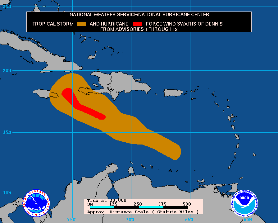
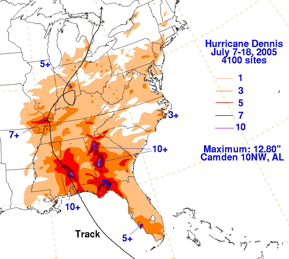
External links
- National Hurricane Center tropical cyclone report on Dennis – A final report issued by the National Hurricane Center regarding Hurricane Dennis, including synoptic history, meteorological statistics, casualties and damage, forecasting critique, and information tables.
- The National Hurricane Center's archive on Hurricane Dennis
- Radar animation of landfall in Florida (credit to Brian McNoldy, RSMAS/Univ of Miami) Archived 2015-06-27 at the Wayback Machine
- The Hydrometeorological Prediction Center's archive on Hurricane Dennis.
- The Hydrometeorological Prediction Center's Rainfall page for Hurricane Dennis.
- Historic Images of Florida Hurricanes (State Archives of Florida)
| 1950s | |
|---|---|
| 1960s | |
| 1970s | |
| 1980s | |
| 1990s | |
| 2000s | |
| 2010s | |
| 2020s | |
| Effects by region | ||
|---|---|---|
| |||||||||||||||||||||||||
| |||||||||||||||||||||||||
Tropical cyclones of the 2005 Atlantic hurricane season | ||
|---|---|---|
 | ||