Vlierzele
Jump to navigation
Jump to search
Vlierzele | |
|---|---|
Village | |
 Former town hall of Vlierzele | |
 Vlierzele Location in Belgium | |
| Coordinates: 50°56′N 3°54′E / 50.933°N 3.900°E | |
| Country | |
| Region | Flemish Region |
| Province | East Flanders |
| Municipality | Sint-Lievens-Houtem |
| Area | |
| • Total | 6.23 km2 (2.41 sq mi) |
| Population (2021)[1] | |
| • Total | 2,169 |
| • Density | 350/km2 (900/sq mi) |
| Time zone | CET |
Vlierzele is a village on the Molenbeek, in the Denderstreek, at the edge of the Flemish Ardennes, the hilly southern part of East Flanders, Belgium. It belongs to the municipality of Sint-Lievens-Houtem.
Etymologically the name Vlierzele is derived from Fliteritsale (in 639) and Vliendersele (in 1412). This is a combination of either the plant name "vlier", which is Dutch for "elder", or the person's name Flether, and "sale" or "sele", which both mean place of residence in Old-Dutch.[2]
The neighbouring villages are:
Gallery
-
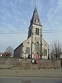 St Fledericus Church
 -
 Villa in Vlierzele
 -
 House in Vlierzele


References
- ^ a b "Bevolking per statistische sector - Sector 41063D". Statistics Belgium. Retrieved 5 May 2022.
- ^ "Heemkundige Kring Land van Rode, webpage about Vlierzele". Retrieved 22 March 2010.
External links
This East Flanders location article is a stub. You can help Wikipedia by expanding it. |