Timbavati River
Jump to navigation
Jump to search
| Timbavati River | |
|---|---|
.jpg) | |
 | |
| Location | |
| Country | South Africa |
| Region | Mpumalanga |
| Physical characteristics | |
| Source | |
| • location | Acornhoek, Mpumalanga |
| • coordinates | 24°35′45″S 31°7′29″E / 24.59583°S 31.12472°E |
| Mouth | |
• location | Confluence with Olifants River, Mpumalanga |
• coordinates | 24°3′18″S 31°40′39″E / 24.05500°S 31.67750°E |
The Timbavati River is a river in Mpumalanga Province of South Africa. It flows mostly through the Kruger National Park after entering the Park adjacent to Maroela Caravan Camp 24°27′20″S 31°23′53″E / 24.45556°S 31.39806°E near Orpen Rest Camp. It is a tributary of the Olifants River and the confluence is at 24°3′18″S 31°40′49″E / 24.05500°S 31.68028°E.
-
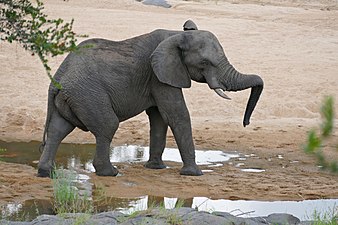 Elephant in the riverbed
 -
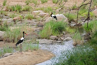 Pair of Saddle-billed storks beside the river
_in_Timbavati_riverbed_(17317498556).jpg)
_couple_in_Timbavati_riverbed_(17173146907).jpg)
See also
Wikimedia Commons has media related to Timbavati River.
References
This Mpumalanga location article is a stub. You can help Wikipedia by expanding it. |
This article related to a river in South Africa is a stub. You can help Wikipedia by expanding it. |
Categories:
- Pages using gadget WikiMiniAtlas
- Use South African English from July 2024
- All Wikipedia articles written in South African English
- Use dmy dates from April 2022
- Articles with short description
- Short description is different from Wikidata
- Coordinates on Wikidata
- Commons category link from Wikidata
- Rivers of Mpumalanga
- All stub articles
- Mpumalanga geography stubs
- South Africa river stubs