Sarangani Bay
Jump to navigation
Jump to search
| Sarangani Bay | |
|---|---|
 View of the bay along the road en route to Glan, Sarangani | |
 North part of Sarangani Bay | |
.svg) Sarangani Bay | |
| Location | Southern Mindanao, Philippines |
| Coordinates | 05°58′N 125°11′E / 5.967°N 125.183°E |
| Max. length | 33 km (21 mi) |
| Max. width | 16 km (9.9 mi) |
Sarangani Bay is a bay located on the southern tip of Mindanao in the Philippines. It opens up to the Celebes Sea on the Pacific Ocean. General Santos, one of the Philippines most important cities and ports, is located at the head of the bay, making the bay one of the busiest and often the site of shipping accidents.[1] The province of Sarangani, created in 1992, is named after the bay.
Gallery
-
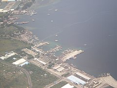 An aerial view of the bay showing the port of General Santos
 -
 Sarangani Bay is one of the protected seascapes in the Philippines.
 -
 Another view of the bay


References
- ^ "2 vessels collide off Sarangani Bay; 2 missing". Philippine Star. 10 August 2011. Retrieved 13 August 2011.
| Authority control databases: National |
|---|
This article about a location in the Philippines is a stub. You can help Wikipedia by expanding it. |
Categories:
- Pages using gadget WikiMiniAtlas
- Coordinates on Wikidata
- Articles using infobox body of water without alt
- Articles using infobox body of water without pushpin map alt
- Articles using infobox body of water without image bathymetry
- Articles with J9U identifiers
- Articles with LCCN identifiers
- Bays of the Philippines
- Protected seascapes of the Philippines
- Landforms of Sarangani
- Landforms of South Cotabato
- All stub articles
- Philippines geography stubs