Nevado de Santa Isabel
(Redirected from Santa Isabel (volcano))
| Nevado de Santa Isabel | |
|---|---|
| Santa Isabel Volcano | |
 Nevado de Santa Isabel in 1985 | |
| Highest point | |
| Elevation | 4,950 m (16,240 ft)[1] |
| Listing | Volcanoes of Colombia |
| Coordinates | 04°49′N 75°22′W / 4.817°N 75.367°W[1] |
| Geography | |
 Nevado de Santa Isabel Location of Nevado de Santa Isabel in Colombia | |
| Location | Tolima |
| Parent range | Central Ranges, Andes |
| Geology | |
| Mountain type | Shield volcano |
| Volcanic belt | North Volcanic Zone Andean Volcanic Belt |
| Last eruption | 1943 |
Nevado de Santa Isabel (English: "The Snowy of Saint Isabel") is a shield volcano straddling the boundaries of the Colombian departments of Tolima, Caldas, and Risaralda, being the highest point of the latter. The volcano lies approximately 10 kilometers southwest of the larger Nevado del Ruiz volcano. Santa Isabel is the third highest peak in Los Nevados National Natural Park. It is a relatively flat volcano with three domes of nearly equal elevation.
Geology
The volcano is located over the Palestina Fault, that crosscuts the underlying El Bosque Batholith of Eocene age, dated at 49.1 ± 1.7 Ma.[2][3]
Gallery
-
 Panorama of Nevado del Ruiz (left), Nevado de Santa Isabel (centre) and Paramillo de Santa Rosa (right)
 -
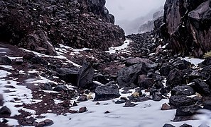 Basalt blocks of Santa Isabel volcano
 -
 Aerial view of the summit of Nevado de Santa Isabel


See also
References
Wikimedia Commons has media related to Nevado de Santa Isabel.
- ^ a b "Santa Isabel". Global Volcanism Program. Smithsonian Institution. Retrieved 2021-03-09.
- ^ Plancha 225, 1998
- ^ González, 2001, p. 50
Bibliography
- González, Humberto (2001). Geología de las planchas 206 Manizales y 225 Nevado del Ruiz - 1:100,000 - Memoria explicativa (PDF) (Report). INGEOMINAS. pp. 1–93. Retrieved 2017-06-09.[dead link]
- Mosquera, Darío; Martín, Pedro; Vesga, Carlos; González, Humberto (1998). Plancha 225 - Nevado del Ruiz - 1:100,000 (Map). INGEOMINAS. p. 1. Retrieved 2017-06-06.
| Western Ranges | | |
|---|---|---|
| Central Ranges | ||
| Eastern Ranges | ||
| Other | ||
| Source | ||
| International | |
|---|---|
| Geographic | |
This Colombian location article is a stub. You can help Wikipedia by expanding it. |
Categories:
- Pages using gadget WikiMiniAtlas
- Articles with short description
- Short description is different from Wikidata
- Coordinates on Wikidata
- Articles containing explicitly cited English-language text
- Commons category link is on Wikidata
- All articles with dead external links
- Articles with dead external links from June 2023
- Articles with VIAF identifiers
- Articles with GVP identifiers
- Mountains of Colombia
- Volcanoes of Colombia
- Andean Volcanic Belt
- Polygenetic shield volcanoes
- Geography of Tolima Department
- Four-thousanders of the Andes
- Holocene shield volcanoes
- Shield volcanoes of South America
- All stub articles
- Colombia geography stubs