Rubene Parish
Jump to navigation
Jump to search
Rubene Parish | |
|---|---|
 Coat of arms | |
 | |
| Country | Latvia |
| Area | |
| • Total | 182.14 km2 (70.32 sq mi) |
| • Land | 179.1 km2 (69.2 sq mi) |
| • Water | 3.04 km2 (1.17 sq mi) |
| Population (1 January 2024)[2] | |
| • Total | 745 |
| • Density | 4.1/km2 (11/sq mi) |
Rubene Parish (Latvian: Rubenes pagasts) is an administrative territorial entity of Jēkabpils Municipality, Latvia. It was an administrative unit of the Jēkabpils District. The administrative center is Rubeņi.
Towns, villages and settlements of Rubene Parish
- Kaldabruņa
- Rubeņi
- Slate
Gallery
-
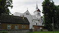
 Lutheran church
 -
 Catholic church
 -
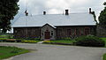
 Rubene schoolhouse
 -
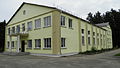
 Local government building
 -
 House of culture
 -
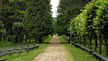 Park
Park -
 Singing square


External links
Wikimedia Commons has media related to Rubene parish.
| Authority control databases: National |
|---|
56°10′17.8″N 26°0′29.3″E / 56.171611°N 26.008139°E
This Latvian location article is a stub. You can help Wikipedia by expanding it. |
- ^ "Reģionu, novadu, pilsētu un pagastu kopējā un sauszemes platība gada sākumā". Central Statistical Bureau of Latvia. Retrieved 18 January 2023.
- ^ "Iedzīvotāju skaits pēc tautības reģionos, pilsētās, novados, pagastos, apkaimēs un blīvi apdzīvotās teritorijās gada sākumā (pēc administratīvi teritoriālās reformas 2021. gadā)". Central Statistical Bureau of Latvia. Retrieved 19 June 2024.
Categories:
- Pages using gadget WikiMiniAtlas
- Articles with short description
- Short description is different from Wikidata
- Pages using infobox settlement with bad settlement type
- Coordinates on Wikidata
- Pages using infobox settlement with no coordinates
- Articles containing Latvian-language text
- Commons category link is on Wikidata
- Articles with LNB identifiers
- Parishes of Latvia
- Jēkabpils Municipality
- All stub articles
- Latvia geography stubs