Rozelle Bay
Jump to navigation
Jump to search
| Rozelle Bay | |
|---|---|
 View of Rozelle Bay and the Anzac Bridge from Federal Park. | |
 Rozelle Bay | |
| Location | Inner West, New South Wales, Australia |
| Coordinates | 33°52′S 151°11′E / 33.867°S 151.183°E |
| Type | Bay |
| Part of | Sydney Harbour |
| Primary inflows | |
| Settlements | Sydney |
Rozelle Bay is a bay located to the south of Glebe Island and the west of Blackwattle Bay, on Sydney Harbour.
The naming of the bay is derived from either the Rosella bird or the Rosella plant, with the latter being more likely, due to the other names in the area that have botanic origins.[1]
A light rail station on the Dulwich Hill Line is named after the bay.
Rozelle Bay is fed by Johnstons Creek[2] and Whites Creek.
The dockyard of the Sydney Heritage Fleet is located on the western shore of Rozelle Bay.
Gallery
-
 A cove of Rozelle Bay
 -
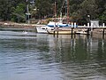
 View of Rozelle Bay Marina from Esther Abrahams Pavilion
 -
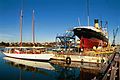 Sydney Heritage Fleet Dockyard
 -
 Looking across the bay, from the Allan truss bridge on Johnston Creek toward the Sydney Boathouse in Rozelle


References
- ^ "Rozelle Bay". Geographical Names Register (GNR) of NSW. Geographical Names Board of New South Wales. Retrieved 23 June 2022.
- ^ "Johnstons Creek (gully)". Geographical Names Register (GNR) of NSW. Geographical Names Board of New South Wales. Retrieved 23 June 2022.
This article related to the geography of Sydney is a stub. You can help Wikipedia by expanding it. |
Categories:
- Pages using gadget WikiMiniAtlas
- Geographic Names Register of NSW not in Wikidata
- Articles with short description
- Short description matches Wikidata
- Use Australian English from August 2013
- All Wikipedia articles written in Australian English
- Use dmy dates from December 2023
- Coordinates on Wikidata
- Articles using infobox body of water without alt
- Articles using infobox body of water without pushpin map alt
- Articles using infobox body of water without image bathymetry
- Bays of New South Wales
- Sydney Harbour
- Inner West
- All stub articles
- Sydney geography stubs